General Thunderstorm Risk for this evening.
Good Monday Morning! We are off and running for another work week around the area and county. The rain chances amp back up today as the front has drifted back north in our direction. With that shift we we see a chance for a General Thunderstorm Risk today
2017 Total Solar Eclipse Forecast Monday 8/14 Update
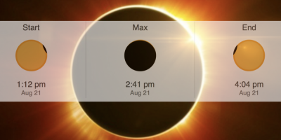
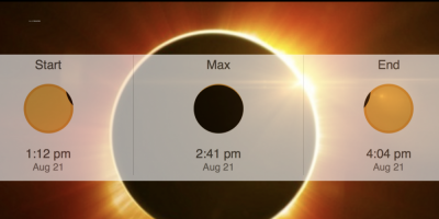
The 2017 Total Solar Eclipse is now just 1 week away! The forecast is changing a little more in our favor from my first look forecast yesterday. I will continue to post these updates daily until we arrive to the time of the Eclipse. Here is the latest look at what we can expect.
Eclipse 2017 Forecast First Look
We are now just 8 days out form the Total Solar Eclipse of 2017. This is the first coast to coast Total Solar Eclipse in over 100 years here in the United States. We are always at the mercy of weather for any outdoor events.

Rain continues to be in the forecast
Good Saturday Morning. Rain will continue to be part of the forecast today. Things will be a little different today as most of the activity will be in the form of isolated showers that will pass through off and on during the day.
Rain Chances Increase Today
We are at the end of the work week. The weekend is in view and it looks to be a wet weekend for us. Beginning with today. The Storms Prediction Center has us with a general thunderstorm risk. However I am keeping an eye to our north and west as the low risk for severe weather is in that area.
General Thunderstorm Risk for this evening.
Rain chances start to pick back up as we begin to march toward the weekend. Today we are listed under a general thunderstorm risk from the Storms Predictions Center.
General Thunderstorm Risk for Tuesday
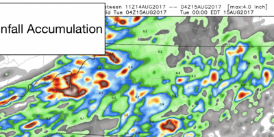
As we move through this Tuesday morning. Rain continues around the area and the county. This is a much needed rain. No issues for a washout but more of an inconvenient period of isolated showers and possibly a thunderstorm or two today.
Rainy Days and Monday
If Rainy Days and Monday get you down. Today is certainly not the day you want weather wise. However, look at the bright side. We need the rain and we will certainly get a decent amount this week.
Rain Chances in the forecast today.
Happy Friday everyone! As we head into the weekend we will be dealing with some rain chances. Those chances move in starting today. Lets take a look at how the day will breakdown for us.

Total Solar Eclipse 2017
On Aug. 21, 2017, people across the United States will see the sun disappear behind the moon, turning daylight into twilight, causing the temperature drop rapidly and revealing massive streamers of light streaking through the sky around the silhouette of the moon.

Announcements & Events
Check back often for important announcements and events that I'll be involved in!
