
The Heat is on today. A cool down is on the way
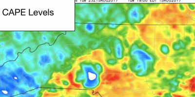
After yesterday's Eclipse the big story weather wise today is the heat. The good news is relief is on the way. More on that shortly. Let's take a look at what we have to go through first!. The Storms Prediction Center has us under a General Thunderstorm Risk for today.
The Eclipse Day Forecast
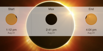
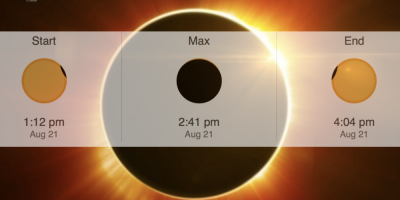
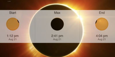
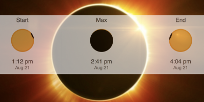
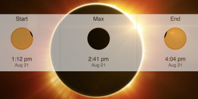
It's finally here! The Day of the Great American Total Solar Eclipse! We have been talking about this event for sometime now and the culmination happens today starting just after 1pm. The weather looks pretty good for our viewing here in the county.
Total Solar Eclipse less than 24 hours away!
We are now less than 24 hours away from the Total Solar Eclipse. The forecast looks great! I wanted to take a moment to give you an update and also share with you a video for safe viewing tips during the eclipse.

Total Solar Eclipse Forecast Update 8/19/17
We are now just 3 days away from the Total Solar Eclipse! The good news now is we can begin to use short range models to determine how good our viewing will be. As of right now things look pretty good for the viewing of the Total Solar Eclipse. Starting with the rain chances.
Marginal Risk For Severe Weather This Evening
We have reached the end of another work week. The rain chances are up for this evening and the Storms Prediction Center has us under a Marginal Risk for Severe Weather this evening
Total Solar Eclipse Forecast Update 8/18/17
The Total Solar Eclipse is now just 3 days away! The Models continue to give us a really good chance for being able to view the Eclipse right here at home! Mostly Sunny skies in the forecast at this point. Cloud cover looks to be pretty thin during the timeframe of the Eclipse.

Total Solar Eclipse Forecast Update 8/17/17
We are now just 4 days away from the Total Solar Eclipse. Over the past few days the models have been flirting with rain chances and cloud cover during the eclipse. This morning they show a much clear picture. As of right now I would give us Mostly Sunny skies for the event.
Total Solar Eclipse Forecast Update 8/16/17
We are now just five days away form the Total Solar Eclipse. The models have been wavering a little over the past few days for what the conditions may be like during the timeframe of the eclipse in our area. Rain chances are slowly putting themselves back into play.
Chance for Isolated Strong Thunderstorms This Evening
Good Tuesday Morning! We certainly had some heavy downpours around the county last night that has led to Dense Fog this morning. Please take your time if out driving and slow it down just a bit. As for today rain chances are still around as the front remains in place for us once again.
Total Solar Eclipse Forecast Update 8/15/177
We are now just six days away for the 2017 Total Solar Eclipse and things are looking up! The models are trending that rain will be east of the area. We are looking at Mostly Sunny skies for the day with a 30% chance of showers and thunderstorms in the afternoon.

Announcements & Events
Check back often for important announcements and events that I'll be involved in!
