


We return to the 80's with a chance of showers late
Good Wednesday Morning! We are halfway through the school and work week! We will see a little warm up today as we return back to the low 80's around the county. Looking for a high of around 81º
Cool Temps today with some pesky drizzle and light rain
Good Tuesday Morning. Today is one of those days that will certainly make you think ahead to fall. It is going to be a cloudy overcast day for at least the morning and early afternoon. We could see some clearing late afternoon and into the evening.
A below average temperature day on tap.
As we begin another school year here in Rowan County. We are going back with a definite fall like feel in the air this morning. The low started out at around 60º in many places around the county. The high today will top out at around 78º
Potential Tropical Cyclone Ten
With the focus over the past few days being on Hurricane Harvey from a national level we have had a tropical storm silently making its presence known in the Atlantic. This storm looks to affect the North Carolina Coastline the question at this point is how strong will it get.

The 2017 Fall Foliage Report
We are quickly approaching the fall season. With the changing of the season and the cooler weather. The leaves will start to change. Once that occurs everyone likes to go see the leaves in the mountains. To get a preview of whats coming our way.
You could see a rain drop today. I wouldn't count on it
The cooler temps are here and the lower humidity is making it feel pretty good outside. The front is still close enough that we could see some very isolated shower activity later this afternoon. I wouldn't look for it though. It will be that scattered.
A cool down begins today. Can't rule out a few showers.
A cold front is moving through the area and bringing a much needed cool down with it. There is also a chance for some isolated showers along the front as it continues to pass through. The good news is the showers will be temporary and isolated.
General Thunderstorm Risk and one more day of Heat!
We are working on our last day of 90º weather at least for the near term. We have a cool down that will start making its way into the county later this evening. The cold front bringing this cool down will bring the chance of showers and storms along with it.
The Heat is on today. A cool down is on the way
After yesterday's Eclipse the big story weather wise today is the heat. The good news is relief is on the way. More on that shortly. Let's take a look at what we have to go through first!. The Storms Prediction Center has us under a General Thunderstorm Risk for today.
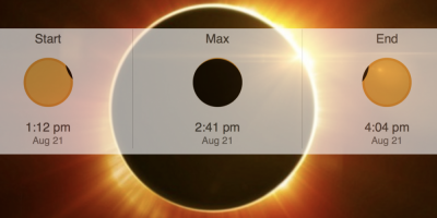
The Eclipse Day Forecast
It's finally here! The Day of the Great American Total Solar Eclipse! We have been talking about this event for sometime now and the culmination happens today starting just after 1pm. The weather looks pretty good for our viewing here in the county.


Announcements & Events
Check back often for important announcements and events that I'll be involved in!
