
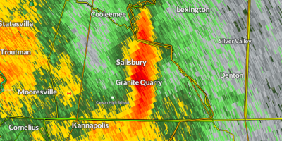
Flash Flood Warning from 1/9/2024 1:48 PM to 6:00 PM EST for Rowan County, NC
Flash Flood Warning
National Weather Service Greenville-Spartanburg SC
148 PM EST Tue Jan 9 2024
The National Weather Service in Greenville-Spartanburg has issued a

Severe Thunderstorm Warning from 1/9/2024 1:10 PM to 2:30 PM EST for Rowan County, NC
The National Weather Service in Greenville-Spartanburg has issued a

Severe Thunderstorm Warning from 1/9/2024 12:35 PM to 1:15 PM EST for Rowan County, NC
The National Weather Service in Greenville-Spartanburg has issued a
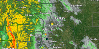
Tornado Watch from 1/9/2024 11:44 AM to 6:00 PM EST for Rowan County, NC
THE NATIONAL WEATHER SERVICE HAS ISSUED TORNADO WATCH 5 IN EFFECT
UNTIL 6 PM EST THIS EVENING FOR THE FOLLOWING AREAS
IN NORTH CAROLINA THIS WATCH INCLUDES 5 COUNTIES
IN PIEDMONT NORTH CAROLINA
CABARRUS GASTON MECKLENBURG
ROWAN UNION NC

Event extended (time). Flood Watch from 1/9/2024 7:00 AM to 10:00 PM EST for Rowan County, NC
...FLOOD WATCH NOW IN EFFECT FROM 7 AM EST TUESDAY THROUGH TUESDAY
EVENING...
* WHAT...Flash flooding caused by excessive rainfall continues to be
possible.
Event extended (both time and area). Flood Watch from 1/9/2024 7:00 AM to 9:00 PM EST for Rowan County, NC
...FLOOD WATCH IN EFFECT FROM TUESDAY MORNING THROUGH TUESDAY
EVENING...
* WHAT...Flash flooding caused by excessive rainfall continues to be
possible.

Wind Advisory from 1/9/2024 10:00 AM to 10:00 PM EST for Rowan County, NC.

...WIND ADVISORY IN EFFECT FROM 10 AM TO 10 PM EST TUESDAY...
* WHAT...South winds 20 to 30 mph with gusts up to 50 mph expected.
BetMGM Announces North Carolina Market Access Agreement with Charlotte Motor Speedway


Tim Dugger and Friends to Perform Nationwide Concert Tour At Speedway Motorsports NASCAR Races
CHARLOTTE, NC (Jan. 5, 2024) -- American country singer and songwriter Tim Dugger and his friends will entertain race fans across the country during a tour of premier NASCAR races at Speedway Motorsports venues, starting at Atlanta Motor Speedway on Sunday, Feb. 25.

Winter Weather Advisory from 1/6/2024 1:00 AM to 1:00 PM EST for Rowan County, NC.
...WINTER WEATHER ADVISORY IN EFFECT FROM 1 AM TO 1 PM EST
SATURDAY...
* WHAT...Mixed precipitation expected. Total snow accumulations of
up to one inch, mainly over the mountains, and ice accumulations
of up to two tenths of an inch.

Announcements & Events
Check back often for important announcements and events that I'll be involved in!
