
A look back at Hurricane Hugo
Please take a moment to visit our local sponsors to let them know that you appreciate their support of our blog.
advertise your local business here »It has been 27 years since Hurricane Hugo made it's landfall in the state of South Carolina. That event was single handedly the main reason I fell in love with weather. The fact that the storm brought so much power that was unforeseen to the county and the area. We did not have the technology in place at that time nor had we ever had a storm move inland so far so fast that it was still a Hurricane by the time it reached Rowan County. I remember being home form school. This was unusual for anything other than the winter storms we would get. The home I lived in at the time had siding blown off of it and trees were falling all around us. I was so amazed by the power of this storm I had to know how these things worked.
Now 27 years later you have Rowan County Weather because of that desire and passion born from Hurricane Hugo
Let's talk about this storm and what occurred.
Hurricane Hugo was a powerful Cape Verde-type hurricane that caused widespread damage and loss of life in the Leeward Islands, Puerto Rico, and the Southeast United States. It formed over the eastern Atlantic near the Cape Verde Islands on September 9, 1989. Hugo moved thousands of miles across the Atlantic, rapidly strengthening to briefly attain category 5 hurricane strength on its journey. It later crossed over Guadeloupe and St. Croix on September 17 and 18 as a category 4 hurricane. Weakening slightly more, it passed over Puerto Rico as a strong category 3 hurricane. Further weakening occurred several hours after re-emerging into the Atlantic, becoming downgraded to a category 2 hurricane. However, it re-strengthened into a category 4 hurricane before making landfall at McClellanville, a small shrimping town up the coast from Charleston, South Carolina, on September 21 with 135-mph sustained winds (gusts to more than 160-mph). It had devolved to a remnant low near Lake Erie by the next day. As of 2016, Hurricane Huge is the most intense tropical cyclone to strike the East Coast north of Florida since 1900.
Hurricane Hugo caused 34 fatalities (most by electrocution or drowning) in the Caribbean and 27 in South Carolina, left nearly 100,000 homeless, and resulted in $10 billion (1989 USD) in damage overall, making it the most damaging hurricane ever recorded at the time. Of this total, $7 billion was from the United States and Puerto Rico, ranking it as the costliest storm to impact the country at the time. Since 1989, however, it has been surpassed by multiple storms and now ranks as the eleventh costliest in the United States.
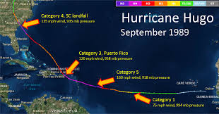
Hurricane Hugo originated as a tropical wave (which also spawned Hurricane Raymond), which moved off the west coast of Africa on September 9. Soon after moving off the African coast, it was classified as Tropical Depression Eleven southeast of the Cape Verde Islands. Winds were initially 30 mph (48 km/h) but they reached 35 mph (56 km/h) soon after. Moving on a steady westward track at 18 knots (21 mph, 33 k/h), Tropical Depression Eleven steadily intensified, becoming Tropical Storm Hugo on September 11 at 1800 UTC. On September 13, Hugo rapidly intensified, and reached hurricane strength 1265 miles (2035 km) east of the Leeward Islands. A low-pressure area to the south caused Hugo to gradually turn to the west-northwest, while the storm was slowly strengthening. Shortly after, Hurricane Hugo began to rapidly intensify; 24 hours after it was classified as a hurricane, it had become a category 2 hurricane. After this bout of rapid strengthening, Hugo began to rapidly deepen, becoming a major hurricane early the next morning.
After becoming a major hurricane, Hugo reached Category 4 strength, while moving slowly west-northwest. The hurricane briefly reached category 5 intensity on September 15 at 1800 UTC. Its maximum sustained winds had increased to 160 mph (260 km/h) and the minimum central pressure had dropped to 918 millibars (27.1 inHg). After peaking in intensity as a category 5 hurricane, Hugo weakened slightly to a category 4 hurricane. In the early hours of September 17, Hugo crossed in between Guadeloupe and Montserrat while its winds were near 140 mph (230 km/h), when hurricane-force winds extended only 45 mi (72 km) from the center. Less than 24 hours later, it made another landfall on the island of St. Croix, with the same intensity. That day, Hurricane Hugo also made landfalls in Puerto Rico, in Vieques and Fajardo, though it was slightly weaker.
Hugo began to accelerate to the northwest soon after exiting eastern Puerto Rico. On September 18, the hurricane was located a couple of hundred miles east of Florida when it began a more northward track, in response to a steering flow associated with an upper-level low pressure area that was moving across the southeastern United States. Hugo then began to strengthen again, and it reached a secondary peak at 1800 UTC on September 21 as a Category 4 hurricane. The maximum sustained winds were 140 mph (230 km/h), while the minimum central pressure was 944 millibars (27.9 inHg). On September 22 at 0400 UTC, Hugo made landfall on Isle of Palms, South Carolina, at his secondary peak as a Category 4 hurricane on the Saffir–Simpson Hurricane Scale with 140-mph sustained winds and a central pressure of 934 millibars (27.6 inHg).
The storm continued inland, and weakened to a Category 1 hurricane as the cloudy eye passed over Rowan County. Hugo continued on the weakening trend weakened to a tropical storm later on the same day over central North Carolina. The storm continued weakening as it moved inland, and on September 23, the storm weakened to a remnant low. Its remnant low continued to accelerate north, and they reached the far northern Atlantic before dissipating on September 25.
The storm caused $7 billion in damage in the United States, surpassing Hurricane Frederic of 1979 as the costliest tropical cyclone in that country. Hugo itself was surpassed by Hurricane Andrew in 1992 and several others over the next few decades. South Carolina suffered the worst impact, where Hugo made landfall as a Category 4 hurricane. In that state alone, 3,307 single family homes were destroyed, 18,171 were inflicted major damage, and 56,580 sustained minor impact, while more than 12,600 mobile homes and 18,000 multi–family houses were either damaged or destroyed.Losses reached at least $5.9 billion and there were thirty-five fatalities reported in South Carolina. There was also significant impact in North Carolina, where 205 structures were destroyed, 1,149 were severely damaged, and 2,638 suffered minor losses. One fatality occurred and damage in North Carolina reached about $1 billion.
North Carolina's coastline suffered significant damage along its southward-facing beaches, including Brunswick County and the Outer Banks.
The storm reached Salisbury in less than seven hours after landfall, not having slowed down when reaching land. By this time, it was still a fairly strong tropical storm with sustained winds of 54 mph (87 km/h) and gusts of 87 mph (140 km/h). This was enough to topple trees across roads and houses, leaving many without power, closing schools for as long as two weeks, and spawning several tornadoes. The storm took many in the area by surprise. Salisbury is roughly 210 miles inland from where the storm made landfall, and many coastal residents from both Carolinas came here to wait out the storm.
By 7:00 am, it was still strong enough to cause heavy rain and tear down hundreds of trees in the area
Damages in that state alone estimated at $1 billion (1989 USD, $1.91 billion 2016 USD).
Due to the extensive damage, the name Hugo was retired following this storm, and will never again be used for an Atlantic hurricane.