
STRONG THUNDERSTORMS WILL IMPACT NORTHWESTERN CABARRUS SOUTHEASTERN LINCOLNSOUTHEASTERN IREDELLNORTHWESTERN MECKLENBURGSOUTHWESTERN ROWAN AND NORTHEASTERN GASTON COUNTIES THROUGH 645 PM EDT.
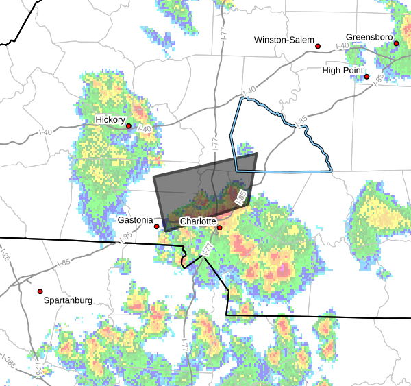
...STRONG THUNDERSTORMS WILL IMPACT NORTHWESTERN CABARRUS...
SOUTHEASTERN LINCOLN...SOUTHEASTERN IREDELL...NORTHWESTERN
MECKLENBURG...SOUTHWESTERN ROWAN AND NORTHEASTERN GASTON COUNTIES
THROUGH 645 PM EDT...
At 610 PM EDT, Doppler radar was tracking a cluster of strong
thunderstorms along a line extending from 6 miles east of
Huntersville to 3 miles northeast of Gastonia. Movement was north at
15 mph.
HAZARD...Wind gusts up to 40 mph and pea size hail.
SOURCE...Radar indicated.
IMPACT...Gusty winds could knock down tree limbs and blow around
unsecured objects. Minor hail damage to outdoor objects is
possible.
Locations impacted include...
Huntersville, Gastonia, Kannapolis, Lincolnton, Northeast Charlotte,
Cornelius, Mt Holly, Davidson, Stanley, and Enochville.
PRECAUTIONARY/PREPAREDNESS ACTIONS...
If outdoors, consider seeking shelter inside a building.
Torrential rainfall is also occurring with these storms and may lead
to localized flooding. Do not drive your vehicle through flooded
roadways.
If on or near Mountain Island Lake and southern portions of Lake
Norman, get out of the water and move indoors or inside a vehicle.
Remember, lightning can strike out to 10 miles from the parent
thunderstorm. If you can hear thunder, you are close enough to be
struck by lightning. Move to safe shelter now! Do not be caught on
the water in a thunderstorm.
Please let our local sponsors know that you appreciate their support of our blog. Take a moment to visit their website linked at the top of this post.
Share this:

Announcements & Events
Check back often for important announcements and events that I'll be involved in!