
A STRONG THUNDERSTORM WILL IMPACT NORTHWESTERN CABARRUS SOUTHEASTERN LINCOLNSOUTHEASTERN IREDELLNORTHWESTERN MECKLENBURG AND SOUTHWESTERN ROWAN COUNTIES THROUGH 800 PM EDT
...A STRONG THUNDERSTORM WILL IMPACT NORTHWESTERN CABARRUS...
SOUTHEASTERN LINCOLN...SOUTHEASTERN IREDELL...NORTHWESTERN
MECKLENBURG AND SOUTHWESTERN ROWAN COUNTIES THROUGH 800 PM EDT...
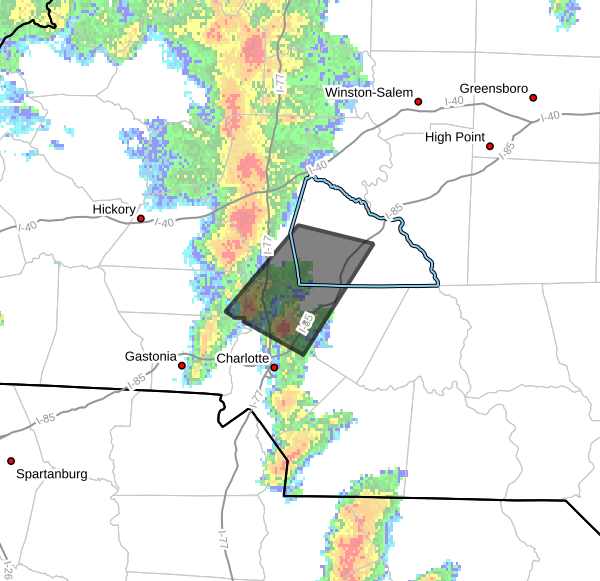
At 723 PM EDT, Doppler radar was tracking a strong thunderstorm near
Huntersville, moving north at 35 mph.
HAZARD...Wind gusts up to 50 mph and half inch hail.
SOURCE...Radar indicated.
IMPACT...Gusty winds could knock down tree limbs and blow around
unsecured objects. Minor hail damage to outdoor objects is
possible.
Locations impacted include...
Huntersville, Kannapolis, Salisbury, Downtown Concord, Northeast
Charlotte, West Concord, Cornelius, Mooresville, Davidson, and China
Grove.
PRECAUTIONARY/PREPAREDNESS ACTIONS...
If outdoors, consider seeking shelter inside a building.
A Tornado Watch remains in effect until 1100 PM EDT for the Piedmont
of North Carolina.
Please let our local sponsors know that you appreciate their support of our blog. Take a moment to visit their website linked at the top of this post.
Share this:

Announcements & Events
Check back often for important announcements and events that I'll be involved in!