
Sunday's Rain Could Bring Some Relief, but Not Everyone Will See the Same Amount
Saturday, November 21, 2026 | Rowan County Weather & Regional Forecast
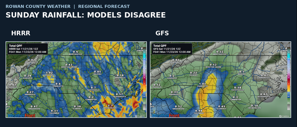
We've been talking about rain returning to North Carolina this weekend, and while that part of the forecast hasn't changed much, there's still an important question: How much rain will actually fall?
The answer isn't as straightforward as you might expect.
Two areas of low pressure are influencing the weather pattern along the Southeast coast. Their development and eventual tracks will help determine where the steadier rain sets up and which communities end up with lighter amounts.
That means we could see some fairly noticeable differences in rainfall totals across North Carolina by the time the system moves away.
What to expect in our four counties
Across Rowan, Davie, Davidson, and Cabarrus counties, Saturday will remain mostly cloudy, with afternoon temperatures generally in the lower 60s.
A few showers are possible during the day, but the better opportunity for rain arrives tonight and continues into Sunday.
Sunday won't necessarily be a complete washout from beginning to end. There could be breaks in the rain, and the timing and coverage of showers will vary across the area.
If you have outdoor plans, I'd keep the possibility of wet conditions in mind, particularly during the morning hours.
Why rainfall totals are still uncertain
The developing coastal weather pattern is more complicated than a single storm moving across the state.
With multiple areas of low pressure involved, the location of the more persistent rain bands remains uncertain. A relatively small shift in how these systems develop could make a meaningful difference in rainfall totals.
Some communities may end up with a decent soaking, while others receive considerably less.
That's why I'm not ready to promise a specific rainfall amount for every county.
We'll have a better idea as the rain develops and we can compare what the radar is showing with the latest forecast guidance.
North Carolina's drought makes this rain important
There's another reason this weekend's forecast deserves attention.
Much of North Carolina has been dealing with unusually dry conditions, and drought has become a growing concern in parts of the state.
A widespread soaking rain would certainly be welcome, but one weekend system won't necessarily erase the rainfall deficits that have developed over time.
Even if some areas pick up a useful amount of rain, longer-term improvement will depend on additional precipitation in the weeks ahead.
What happens after Sunday?
Monday looks like a nice break in the unsettled weather.
Temperatures should rebound into the lower 70s across our four-county area, with some sunshine returning.
A cold front will then bring cooler air into North Carolina, leaving Tuesday considerably cooler, with afternoon highs generally in the upper 50s.
Our attention then turns to another developing system that could bring rain back into the forecast Wednesday and possibly into Thanksgiving Day.
That second system remains important because Wednesday is one of the busiest travel days of the year. We also have local holiday events, including the 3 PM 'Tis the Season Spectacular parade in Salisbury.
It's still too early to pin down exactly when Wednesday's rain will arrive or how much will fall.
What I'll be watching
For the remainder of Saturday, my main focus will be the development of the rain to our south and how it spreads into North Carolina overnight.
I'll also be watching whether the steadier rainfall favors the mountains and foothills, the Piedmont, or areas farther east.
There is an opportunity for some much-needed rain, but the distribution may be uneven.
We'll continue following the system through Sunday and adjust the forecast as the details become clearer.