
Weekend Rain Arrives Tonight as Another System Raises Thanksgiving Travel Concerns
The weekend is getting underway with plenty of clouds across Rowan, Davie, Davidson, and Cabarrus counties. While much of Saturday should remain relatively quiet, rain chances will increase later today and especially tonight as an area of low pressure develops near the Southeast coast.
This is the first of two weather systems we're watching over the next several days. The second could bring another round of rain Wednesday into Thanksgiving Day, potentially affecting holiday travel and outdoor events across North Carolina.
Rain Becomes More Likely Tonight
Saturday afternoon temperatures should reach the lower 60s across our four-county area, with clouds dominating the sky.
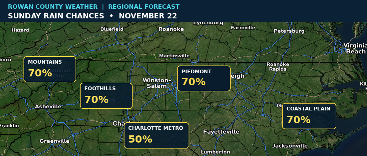
Rain chances will gradually increase as low pressure develops near the Southeast coast and moves northeast. The better opportunity for widespread showers arrives Saturday night and continues into Sunday.
The latest forecast guidance continues to show uncertainty in how much rain will fall. Some solutions bring relatively light rainfall inland, while others produce more substantial amounts.
For now, the main message is that Sunday could be wet, particularly during the morning hours. Rain chances should begin decreasing later in the day as the system moves away.
This rainfall would be welcome across portions of North Carolina that have been dealing with unusually dry conditions.
Monday Brings a Brief Warmup
After the weekend rain moves out, Monday should bring a noticeable improvement.
Sunshine returns, and afternoon temperatures could reach the lower 70s across much of our area.
Our current forecast calls for highs near 72 in Rowan, Davie, and Davidson counties, with Cabarrus County reaching around 73 degrees.
That warmup won't last long.
A cold front moving through Monday night into Tuesday will bring another change in temperatures, with highs falling back into the upper 50s Tuesday.
Wednesday's Weather Could Affect Holiday Plans
The next system we're watching could have a greater impact on holiday schedules.
Forecast guidance suggests another area of low pressure may develop across the Southeast during the middle of next week, bringing increasing rain chances Wednesday into Thanksgiving Day.
Wednesday currently looks considerably cooler, with highs ranging from around 52 to 53 degrees across Rowan, Davie, Davidson, and Cabarrus counties.
The timing of the rain remains uncertain, and that's particularly important for people traveling ahead of Thanksgiving.
We're also watching the forecast for Wednesday's Tis the Season Spectacular Thanksgiving Parade in Salisbury, scheduled to begin at 3 PM.
At this point, it's too early to say whether rain will affect the parade itself. However, the possibility is there, and we'll continue monitoring the timing as newer forecast information becomes available.
Anyone planning to travel Wednesday should check the forecast again before leaving, especially if their route takes them across different parts of North Carolina.
A Look Across North Carolina
The weekend coastal system could produce varying rainfall amounts across the state, with the greatest uncertainty involving how far inland the more substantial precipitation develops.
By the middle of next week, colder air will spread across much of North Carolina.
In the mountains, temperatures could become cold enough for some wintry precipitation early Wednesday if moisture arrives at the right time. At this point, significant accumulation is not expected, but mountain travelers should monitor the forecast.
Elsewhere, rain appears to be the primary precipitation concern.
What Happens Next?
Our immediate focus remains on the rain arriving tonight and Sunday.
After Monday's warmup, attention will shift toward the next system and how it could affect Wednesday's travel, holiday parades, and Thanksgiving Day plans.
There is still considerable uncertainty with the midweek system, so the forecast will likely undergo additional adjustments over the next several days.
We'll continue updating the forecast for Rowan, Davie, Davidson, and Cabarrus counties while also monitoring significant weather developments across North Carolina.