

Weekend Soaking Rain Looking More Likely — Saturday Night Through Sunday Could Be Wettest
After several days of sunshine and temperatures that feel more like late summer than the beginning of October, a significant change is taking shape for the Rowan County Weather region this weekend.
Confidence continues to increase that widespread rain will develop across Rowan, Davie, Davidson and Cabarrus counties, with Saturday night through Sunday looking like the wettest portion of the weekend.
And compared with previous forecasts, the rainfall signal is becoming a little stronger.
First, Two More Warm Days
Before the rain arrives, we still have plenty of warmth to get through.
High temperatures today will reach the mid-80s, followed by another sunny and even warmer Friday. Most of the region should reach the upper 80s Friday, with Davidson and Cabarrus counties approaching 89°.
Friday should be the warmest day of the week.
The dramatic change begins Saturday as a cold front moves south through the Carolinas and cold-air damming — commonly called a Carolina wedge — begins developing behind it.
The front has recently been trending toward a slightly earlier arrival, which has also resulted in cooler forecast temperatures for Saturday. Pasted markdown
Rain Chances Increase Saturday
Saturday does not necessarily look like an all-day washout, particularly during the morning.
However, clouds will increase and showers should become more numerous as the day progresses.
Current rain chances range from around 60% in Rowan and Davie counties to 70% in Davidson County and 80% in Cabarrus County.
The more significant rain is expected to develop later Saturday and especially Saturday night.
That's when the wedge becomes firmly established and deeper moisture begins moving over the cooler air near the surface.
Saturday Night Through Sunday Looks Wettest
This remains the portion of the forecast I'm watching most closely.
Rain should become widespread Saturday night and continue through much of Sunday. The latest forecast discussion has also noted that weekend rainfall totals have trended slightly higher. Pasted markdown
The setup favors a widespread soaking rainfall. Atmospheric moisture will be high enough that showers could become efficient rain producers, meaning locally heavier rainfall will be possible even without strong thunderstorms. Pasted markdown
Davidson County's forecast carries an additional signal worth watching. Confidence is increasing that a wave of low pressure could travel along the stalled front and enhance rainfall intensity and totals Saturday night into Sunday. Pasted markdown
That could make the Saturday night-Sunday period considerably wetter than the first half of Saturday.
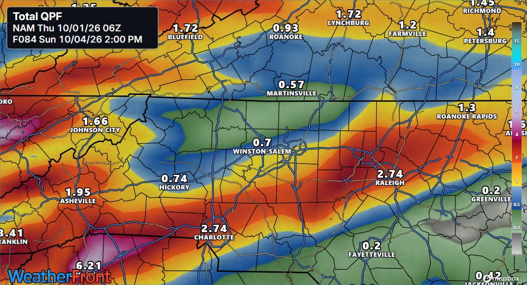
Latest NAM Shows Significant Rainfall Potential
The latest 06Z NAM model run adds another piece to the picture.
Its accumulated precipitation forecast through 2 PM Sunday depicts a swath of considerably heavier rainfall extending across portions of the Charlotte metro and central North Carolina.
The graphic shows approximately 2.74 inches near Charlotte and 2.74 inches near Raleigh, while amounts farther north are considerably lower, including around 0.70 inch near Winston-Salem and 0.57 inch near Martinsville.
For the Rowan County Weather coverage area, the graphic places the region near a fairly sharp gradient between the heavier totals to the south and lighter amounts farther north.
That detail is important.
These NAM totals should not be treated as a literal rainfall forecast for any individual county. This is one model run, and exactly where the heaviest rainfall axis develops remains uncertain. But it illustrates the potential for rainfall totals to increase substantially if the deeper moisture and wave of low pressure align over our area.
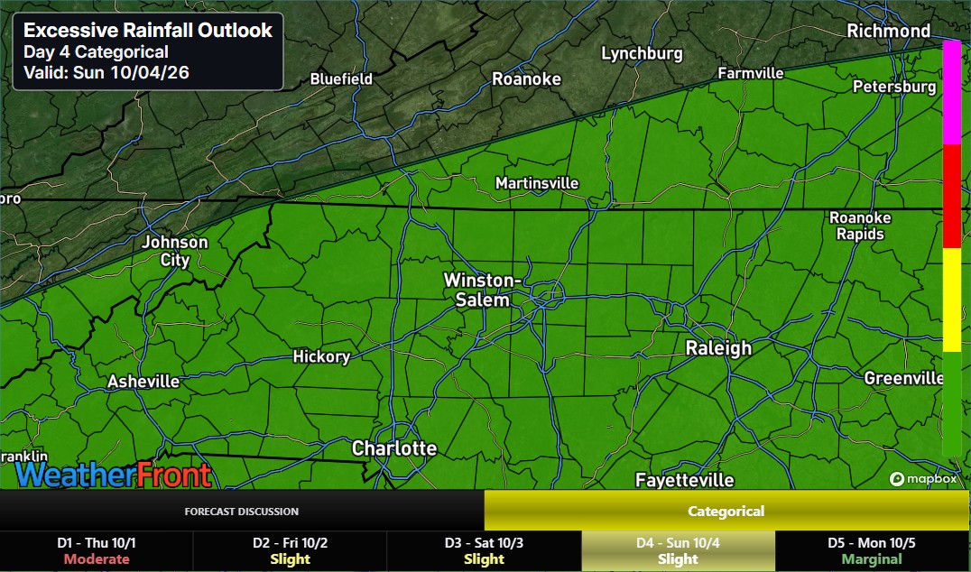
Excessive Rainfall Outlook Bears Watching
The attached Day 4 Excessive Rainfall Outlook for Sunday also highlights the region for at least some potential for excessive rainfall.
That doesn't mean flooding is guaranteed.
Rather, it reinforces the idea that Sunday's rainfall setup deserves attention, particularly if repeated or heavier showers move across the same locations.
For now, the broader forecast discussion continues to favor a beneficial soaking rainfall for most locations with localized heavy rainfall possible, rather than signaling widespread excessive rainfall. Pasted markdown
I'll continue watching whether that assessment changes as higher-resolution guidance gets closer to the event.
Sunday Will Feel Completely Different
Rain isn't the only story.
Temperatures will tumble behind the front as northeast winds strengthen and the wedge takes hold.
Consider the expected change:
Friday: 88–89° across much of the region
Sunday: roughly 66–68°
That's a drop of more than 20 degrees in daytime temperatures in about 48 hours.
Sunday could be one of those classic Carolina wedge days — cloudy, damp, breezy and chilly, with temperatures barely moving during the afternoon.
When Does It End?
Rain should begin tapering Sunday night as the front finally pushes farther south and drier air begins filtering into the region.
Monday currently looks considerably better, although clouds could linger.
Then another push of fall air arrives.
The broader pattern favors highs mainly in the 60s to lower 70s Tuesday and Wednesday, with cooler nights as a much more seasonable early-October air mass settles into the Carolinas. Pasted markdown
Bottom Line
The weekend forecast is becoming clearer:
Saturday morning: Not necessarily a washout.
Saturday afternoon: Rain chances increase.
Saturday night: Widespread rain becomes increasingly likely.
Sunday: Wettest portion of the weekend, with periods of soaking and potentially locally heavy rain.
Sunday night: Rain gradually tapers.
Monday: Improving.
The biggest question now isn't whether we're going to see rain. It's exactly where the heaviest rainfall axis develops and how much ultimately falls.
I'll be watching that closely over the next couple of days as additional model runs come in.
— Rowan County Weather