
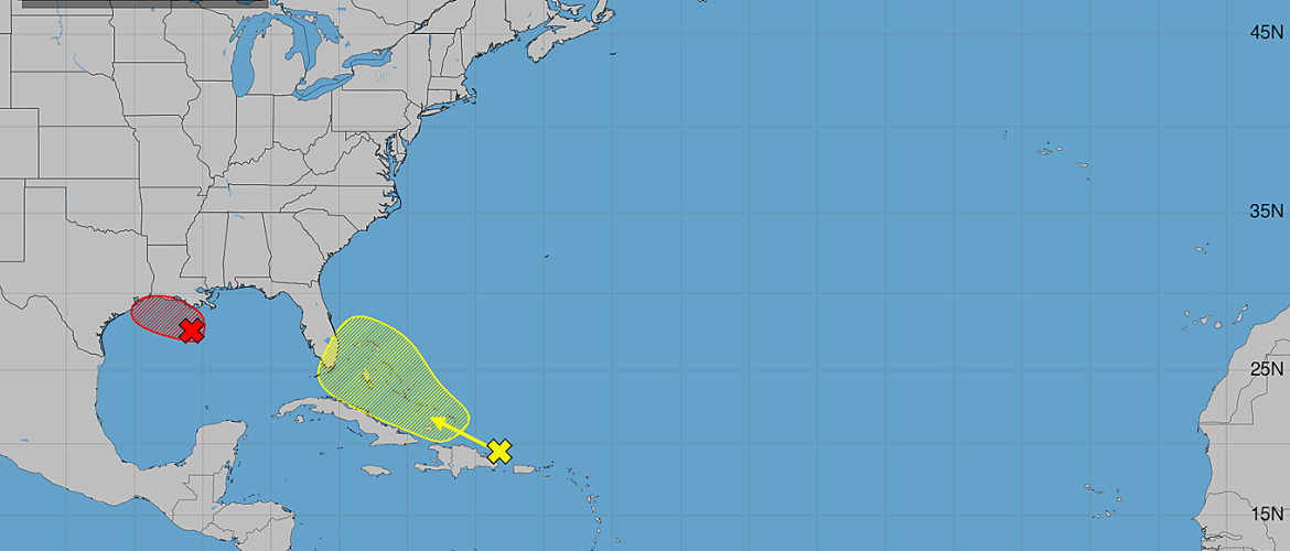
Tropical Atlantic Update: AL97 Likely to Develop in Gulf While Remnants of Dolly Could Get Another Chance
The final day of August begins with two areas to watch across the Atlantic basin, including one system that could become a tropical depression or tropical storm before reaching the Gulf Coast.
The more immediate concern is AL97 in the northern Gulf of America, where the chance of tropical development has increased to 70 percent. Meanwhile, the remnants of Tropical Storm Dolly continue moving quickly through the northeastern Caribbean. Dolly is not expected to reorganize immediately, but conditions could become more favorable again later this week.
AL97: Tropical Depression or Storm Likely Before Landfall
An area of low pressure designated AL97 is located more than 100 miles south of the southern Louisiana coast.
The system continues to produce a small but concentrated area of showers and thunderstorms. Recent satellite wind data indicated that the circulation had not become significantly better organized, although winds around the system were already reaching approximately 30 to 35 mph.
Despite its current organization, conditions should allow additional development as AL97 moves slowly west-northwestward.
As of the 2 AM Monday outlook, the chance of development stands at:
Next 48 hours: 70 percent
Next 7 days: 70 percent
A short-lived tropical depression or tropical storm is likely to form before the system reaches the Upper Texas or southwestern Louisiana coastline sometime tonight or Tuesday morning.
Because the system is relatively close to land, it doesn't have a tremendous amount of time over water to organize. However, residents along portions of the Texas and Louisiana coastlines should pay close attention today.
Tropical Storm Watches or Warnings could become necessary for portions of the southwestern Louisiana and Upper Texas coasts.
An Air Force Reserve reconnaissance aircraft is also scheduled to investigate AL97 later this morning. That mission should provide much better information about the system's circulation, winds and organization.
Heavy Rain Could Be the Bigger Concern
Whether AL97 officially receives a name before reaching the coast isn't the only concern.
The system is expected to produce locally heavy rainfall across portions of southwestern Louisiana and the Upper Texas coast during the next several days.
This is an important reminder that impacts from a tropical system don't depend on whether it receives a name. Flooding rainfall can occur even if AL97 remains relatively weak or has only a brief window as a tropical cyclone.
Remnants of Dolly Continue Through the Caribbean
The second area being monitored is one we've already been following — the remnants of Tropical Storm Dolly.
Dolly is currently a surface trough rather than an organized tropical cyclone. Its remnants are producing showers and thunderstorms from Hispaniola eastward toward the northern Leeward Islands.
For now, redevelopment is unlikely.
Strong upper-level winds should prevent Dolly's remnants from reorganizing during the next day or two as the system races west to west-northwest at approximately 20 to 25 mph.
Development chances currently stand at:
Next 48 hours: Near 0 percent
Next 7 days: 20 percent
But that doesn't necessarily mean we're finished watching Dolly.
Could Dolly Redevelop Later This Week?
This is where the forecast becomes more interesting.
Conditions could become somewhat more favorable for tropical development by the middle of the week as the remnants approach the southern Bahamas or Florida Straits.
That gives the system at least some opportunity to reorganize.
At only a 20 percent seven-day development chance, redevelopment is certainly not expected at this point. But considering the system's projected path toward a potentially more favorable environment, it remains worth monitoring.
Regardless of redevelopment, locally heavy rainfall and gusty winds are possible across portions of the Leeward Islands, Virgin Islands, Puerto Rico and Hispaniola over the next couple of days.
What Does This Mean for North Carolina?
Neither system represents an immediate tropical threat to North Carolina.
AL97 is expected to remain confined to the Gulf Coast, with Texas and Louisiana facing the most immediate impacts.
The remnants of Dolly require a little more patience.
Its eventual track and ability to reorganize will depend heavily on atmospheric conditions later this week. If the system reaches the Bahamas or Florida Straits intact, we'll have a better idea of whether redevelopment is becoming more realistic and where it could potentially go from there.
There is no reason for concern in North Carolina based on the current forecast. For now, this is simply something I'll continue watching.
The Bottom Line
The tropics remain active as August comes to an end.
AL97: 70% development chance. A short-lived tropical depression or tropical storm is likely before reaching southwestern Louisiana or the Upper Texas coast tonight or Tuesday morning.
Remnants of Dolly: Near 0% development chance during the next 48 hours and 20% through seven days. Strong upper-level winds should prevent immediate redevelopment, but conditions could become more favorable near the southern Bahamas or Florida Straits around midweek.
The reconnaissance mission into AL97 later this morning could provide the next important update, while Dolly's remnants will need several more days before we know whether they have a legitimate opportunity to reorganize.
I'll continue tracking both systems and provide updates as conditions change.