
Two Tropical Systems to Watch as the Remnants of Dolly Move Toward the Gulf
The Atlantic tropics remain active as we close out August, with two areas being monitored for possible tropical development.
As of Sunday morning, August 30, neither system has a high chance of development. However, both are worth watching over the next several days, particularly as the remnants of Tropical Storm Dolly continue moving westward toward the Gulf.
For North Carolina, there is no immediate tropical threat from either system. At Rowan County Weather, I’ll continue monitoring both as we head into the first week of September.
Remnants of Dolly Moving Through the Caribbean
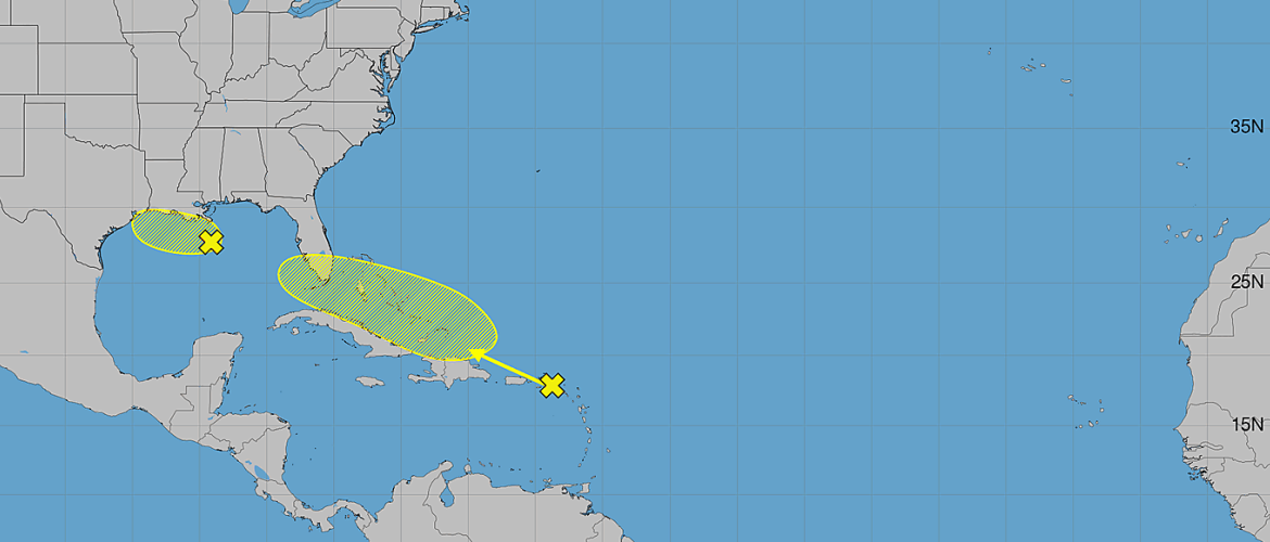
The first area being monitored is a strong tropical wave associated with the remnants of Tropical Storm Dolly.
The system is producing showers and thunderstorms from Puerto Rico eastward across the Virgin Islands and northern Leeward Islands.
Satellite information and surface observations indicate that Dolly no longer has a closed surface circulation, meaning it is no longer an organized tropical cyclone.
The system is moving quickly toward the west to west-northwest at around 25 mph.
Development is considered very unlikely during the next day or two as the system moves through the northeastern Caribbean.
Development Chances
Formation chance through 48 hours: Near 0%
Formation chance through 7 days: 20%
While redevelopment isn't expected in the short term, Dolly's remnants could still produce locally heavy rainfall and gusty winds across portions of the Leeward Islands, Virgin Islands and Puerto Rico over the next couple of days.
The part of the forecast that has my attention comes later in the week.
Conditions could become somewhat more favorable for redevelopment around the middle of the week as the tropical wave reaches the southeastern Gulf.
That doesn't mean Dolly will redevelop. A 20% seven-day development probability remains low. It does, however, mean this system shouldn't be completely written off just yet.
AL97 Being Monitored in the Northern Gulf
A second system, designated AL97, is being monitored much closer to the United States.
An area of low pressure is located approximately 125 miles south of the southeastern Louisiana coast.
Showers and thunderstorms associated with the low have become more concentrated, but surface observations indicate that the system has not strengthened into a tropical depression or tropical storm.
Some slow development remains possible as AL97 drifts west to west-northwest across the northern Gulf over the next couple of days.
Development Chances
Formation chance through 48 hours: 30%
Formation chance through 7 days: 30%
Those probabilities remain in the low category, but residents along the Louisiana and Upper Texas coasts should continue monitoring the system.
Even without significant tropical development, areas of low pressure over the warm waters of the Gulf can produce periods of locally heavy rainfall and gusty weather near the coast.
What Does This Mean for North Carolina?
At this point, neither system represents an immediate tropical threat to North Carolina.
AL97 is expected to remain over the northern Gulf while drifting generally westward, keeping its primary area of interest along portions of the Gulf Coast.
The remnants of Dolly have a much longer journey ahead.
Dolly's remnants are moving quickly through the northeastern Caribbean and are expected to continue generally westward. The system could reach the southeastern Gulf around the middle of the week, where conditions may become somewhat more favorable for redevelopment.
There is far too much uncertainty at this stage to speculate about where the system could ultimately go if redevelopment occurs.
The important thing right now is simply to keep watching it.
Two Systems, Both With Low Development Chances
Here's where things stand Sunday morning:
Remnants of Dolly
- Moving west to west-northwest around 25 mph
- Heavy rain and gusty winds possible across parts of the northeastern Caribbean
- Near 0% chance of development through 48 hours
- 20% chance of development through seven days
- Conditions could become more favorable in the southeastern Gulf around midweek
AL97
- Located about 125 miles south of southeastern Louisiana
- Thunderstorm activity has become more concentrated
- Moving slowly west to west-northwest
- 30% chance of development through 48 hours
- 30% chance of development through seven days
- Louisiana and Upper Texas coastal areas should continue monitoring it
What I'll Be Watching
The tropical forecast isn't particularly threatening this morning, but there are a few things worth following.
First will be whether AL97 can develop a better-defined circulation while it remains over the northern Gulf.
Second — and potentially more interesting for the longer-range forecast — will be what happens to the remnants of Dolly after they move through the Caribbean.
If the tropical wave survives its fast trip westward and reaches the southeastern Gulf with enough organization remaining, we'll need to see whether the environment actually becomes favorable enough for redevelopment.
For now, development chances remain low.
There is no reason for anyone in North Carolina to be concerned about either system at this time. This is simply the time to remain aware and watch how the forecast evolves.
I'll continue tracking both systems and provide updates if there are meaningful changes in organization, development chances or potential impacts.