
Tropical Storm Dolly Forms in the Atlantic, Expected to Be Short-Lived
The Atlantic has its newest named storm.
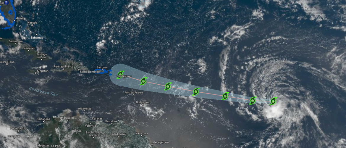
Tropical Storm Dolly formed Thursday morning, August 27, after Invest 96L developed a well-defined circulation and increasingly organized thunderstorm activity over the central tropical Atlantic.
The National Hurricane Center initiated advisories on Dolly at 11 AM Thursday, making it the fourth named system designated with an Atlantic cyclone number during the 2026 season.
While Dolly has organized enough to become a tropical storm, the environment ahead of it is expected to become increasingly hostile. Current guidance indicates the storm could lose its tropical cyclone structure before reaching the Leeward Islands.
Dolly Becomes a Tropical Storm
Satellite imagery Thursday morning showed that Invest 96L had developed a well-defined center accompanied by organized deep convection.
Some northwesterly wind shear is already affecting the system, resulting in most of its thunderstorm activity being displaced to the southern side of the circulation rather than concentrated around the center.
Satellite-derived wind measurements indicated maximum sustained winds near 40 mph, supporting the upgrade to Tropical Storm Dolly.
Dolly is moving quickly toward the west.
Moving West at a Fast Pace
Dolly's initial motion was estimated at approximately 275 degrees at 21 knots, or roughly 24 mph.
That's a fast-moving tropical cyclone.
A strong ridge of high pressure across the central Atlantic should continue steering Dolly quickly westward during the next couple of days.
Forecast models are in relatively good agreement on a track toward the Leeward Islands, although Dolly's speed will be an important part of the forecast.
The National Hurricane Center's initial track is positioned toward the faster and southern side of the overall model guidance.
Dolly Could Strengthen a Little First
There may be a brief opportunity for Dolly to strengthen before conditions deteriorate.
The environment around the storm remains supportive enough Thursday for some additional organization, so slight intensification is possible in the short term.
That window isn't expected to remain open for long.
Beginning Friday, Dolly should encounter several factors working against it:
- Increasing southwesterly wind shear
- Dry air in the atmosphere
- Very fast forward motion
- Influence from an upper-level trough over the central Atlantic
Together, those factors should make it increasingly difficult for Dolly to maintain an organized tropical circulation.
Dolly May Not Reach the Islands as a Tropical Storm
Current forecast guidance strongly favors Dolly weakening and eventually opening into a strong tropical wave before reaching the Leeward Islands.
That means Dolly could technically no longer be classified as a tropical cyclone by the time it approaches the islands.
But losing the name doesn't necessarily eliminate the impacts.
A former tropical cyclone can still carry considerable tropical moisture, produce gusty winds and generate very heavy rainfall.
That's the primary concern with Dolly as it moves west.
Heavy Rain Could Reach the Caribbean
Even though Dolly is expected to lose its tropical cyclone structure, moisture associated with the system could begin affecting the Leeward Islands late Saturday into Sunday.
Heavy rainfall could then spread toward the Virgin Islands, Puerto Rico and Hispaniola Sunday into Monday.
The primary concern will be flash flooding, particularly across mountainous terrain where tropical rainfall can be enhanced and runoff can develop quickly.
Anyone in those areas should continue monitoring the forecast even if Dolly weakens before arriving.
The distinction between a tropical storm and a tropical wave matters meteorologically, but heavy rainfall doesn't care whether a system still has a name attached to it.
What About the United States?
At this point, Dolly does not represent a threat to North Carolina or the continental United States.
The immediate forecast calls for Dolly to weaken substantially as it approaches the northeastern Caribbean.
There is no reason for anyone in North Carolina to be concerned about direct impacts from Dolly based on the current forecast.
I'll continue monitoring what remains of the system as it moves westward, but the main concern over the next several days will be potential heavy rainfall across portions of the Caribbean.
About the Name Dolly
There is an unusual coincidence surrounding the timing of this storm's name.
The National Hurricane Center specifically addressed it in its first discussion Thursday, explaining that the timing of the name Dolly is purely coincidental.
Atlantic tropical cyclone names come from six predetermined rotating lists established by the World Meteorological Organization's Region IV Hurricane Committee.
The name Dolly replaced Diana following the 1990 Atlantic hurricane season and was first used in 1996.
In other words, the name wasn't selected because of any current event. Dolly was simply the next predetermined name on the 2026 Atlantic list.
What I'm Watching Next
There are two parts of Dolly's forecast I'll be watching particularly closely.
First is whether the storm manages to strengthen during its brief window of somewhat favorable conditions Thursday.
Second — and more important — is how quickly Dolly deteriorates once stronger wind shear and dry air begin affecting the circulation Friday.
Forecast guidance currently has a strong consensus that Dolly will lose its tropical cyclone structure before reaching the Leeward Islands.
Even if that happens, I'll continue watching the system's moisture as it approaches the Caribbean because heavy rainfall and flash flooding could remain hazards long after Dolly stops being a tropical storm.
Bottom Line
Tropical Storm Dolly has formed in the central Atlantic with maximum sustained winds near 40 mph.
Some slight strengthening is possible in the short term, but conditions are expected to become increasingly hostile beginning Friday.
Dolly is forecast to:
- Move quickly westward toward the Leeward Islands
- Encounter increasing wind shear and dry air
- Weaken and likely become a strong tropical wave before reaching the islands
- Bring the potential for heavy rainfall to the Leeward Islands late Saturday into Sunday
- Potentially spread heavy rainfall into the Virgin Islands, Puerto Rico and Hispaniola Sunday and Monday
There is currently no threat to North Carolina or the continental United States.
I'll continue monitoring Dolly and provide updates if there are meaningful changes to its intensity, track or expected impacts.
Rowan County Weather & Regional Forecasts