
Two Areas to Watch in the Atlantic as Development Chances Reach 50%
The Atlantic basin continues to show signs of activity as we move deeper into the heart of hurricane season. As of early Monday morning, August 24, two areas are being monitored for possible tropical development, and both now have a 50% chance of formation during the next seven days.
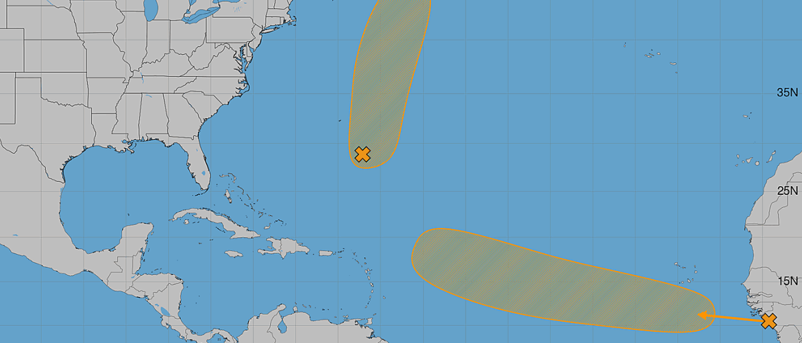
One system, designated AL95, is already producing showers and thunderstorms over the central subtropical Atlantic. Farther east, a tropical wave moving off the coast of Africa could gradually organize as it travels westward across the tropical Atlantic later this week.
Neither system currently poses a threat to the Carolinas, but the eastern Atlantic disturbance will be worth monitoring over the coming days because of its expected westward track.
AL95: Central Subtropical Atlantic
An area of low pressure designated AL95 is located a few hundred miles southeast of Bermuda and is producing showers and thunderstorms.
Additional development remains possible, and the system could become a short-lived tropical depression or tropical storm during the next couple of days.
Development chances currently stand at:
- Next 48 hours: 50%
- Next 7 days: 50%
The good news for our region is the expected track. AL95 is forecast to move northward and then north-northeastward, passing well northeast of Bermuda.
Based on the current forecast pattern, AL95 does not pose a threat to North Carolina or the United States East Coast.
Its window for development may also be relatively brief, which is why any tropical depression or storm that forms is currently expected to be short-lived.
New Tropical Wave Emerging From Africa
The second area may be more important to watch over the longer term.
A tropical wave is expected to move off the west coast of Africa later Monday, and an area of low pressure could develop in association with the wave early this week.
Environmental conditions are expected to be marginally favorable for development.
Formation chances currently stand at:
- Next 48 hours: 10%
- Next 7 days: 50%
A tropical depression could form during the middle to latter part of this week as the disturbance moves generally westward at approximately 15 to 20 mph across the eastern and central tropical Atlantic.
Unlike AL95, this disturbance is expected to move westward across the Atlantic rather than quickly turning toward the north.
That does not mean the system will eventually threaten the United States or the Carolinas. It is far too early to determine where the disturbance will ultimately go, whether it will develop, or what conditions it will encounter farther west.
However, its projected movement means this will be the system I pay closer attention to during the coming week.
Why It's Too Early to Talk About a U.S. Threat
Whenever a tropical wave emerges from Africa and begins moving westward, it's tempting to start looking several days down the road and wondering whether it could eventually approach the Caribbean or United States.
At this stage, that would be getting ahead of the forecast.
The disturbance hasn't even developed into a tropical depression, and atmospheric conditions, steering currents and the strength of the system can all change considerably during a journey across the Atlantic.
The important information right now is that development is possible later this week and the system is expected to continue generally westward across the tropical Atlantic.
There will be plenty of time to evaluate any potential impacts if the system becomes better organized.
Approaching the Peak of Atlantic Hurricane Season
The increase in activity isn't unusual for late August.
We are entering the climatologically most active portion of the Atlantic hurricane season. Tropical waves regularly move from Africa into the Atlantic during this period, while ocean temperatures and atmospheric conditions across portions of the basin can become increasingly supportive of tropical development.
The statistical peak of the Atlantic hurricane season occurs around September 10, so the next several weeks are traditionally an important period for monitoring the tropics.
An active tropical Atlantic does not necessarily mean North Carolina will be affected. Many disturbances never develop, and many tropical cyclones remain over open water or turn away from the United States.
What I'm Watching
There are currently two areas to monitor:
AL95: A 50% development chance during the next 48 hours and seven days. It could briefly become a tropical depression or storm, but its expected northward and north-northeastward movement keeps it well away from the Carolinas.
Eastern Tropical Atlantic: Only a 10% development chance during the next 48 hours, increasing to 50% during the next seven days. This disturbance could become a tropical depression later this week while moving westward across the Atlantic.
Of the two, the eastern Atlantic disturbance deserves more attention over the longer term because of its westward movement, but there is currently no reason for concern in North Carolina.
I'll continue monitoring both systems and any additional tropical waves that emerge as we head toward the peak of hurricane season.
Bottom line: The Atlantic is becoming more active. AL95 may briefly develop but is expected to remain safely out over the Atlantic. A new tropical wave emerging from Africa has a 50% chance of development during the next seven days and will be one to watch as it moves westward. For now, there are no tropical threats to Rowan County, the Charlotte region or North Carolina.