
Atlantic Tropical Activity Increasing as Development Chances Rise
The Atlantic continues to show signs of becoming more active as we move deeper into the heart of hurricane season.
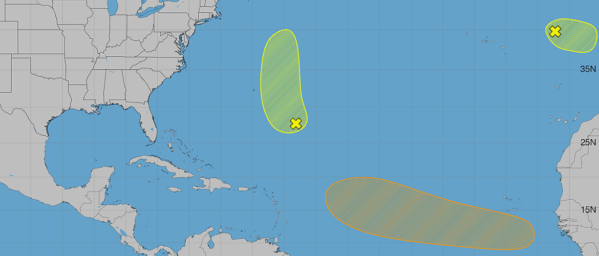
As of Saturday evening, August 22, three areas are being monitored across the Atlantic for possible tropical or subtropical development. Two of those disturbances have seen their development chances increase since Saturday morning, including a tropical wave expected to emerge from Africa that could potentially become a tropical depression next week.
There remains no immediate tropical threat to North Carolina, but there are a couple of systems that will deserve attention over the coming days.
Northeastern Atlantic System Remains at 20%
A strong non-tropical area of low pressure remains several hundred miles west of Portugal.
The system could briefly acquire tropical or subtropical characteristics Saturday night or Sunday as it moves east-southeast at approximately 10 to 15 mph toward Portugal and northwestern Spain.
Its opportunity for development will be relatively short. Environmental conditions are expected to become unfavorable by Sunday night.
Development chances:
- Next 48 hours: 20%
- Next 7 days: 20%
There has been no change in the development probabilities since Saturday morning.
Because of the system's location and expected movement toward Europe, it poses no threat to North Carolina or the United States.
Development Chances Increase East-Southeast of Bermuda
There has been a more noteworthy change with the disturbance over the central subtropical Atlantic.
A broad area of low pressure has now formed in association with showers and thunderstorms located a few hundred miles east-southeast of Bermuda.
Additional gradual development is possible during the next several days.
The system is expected to drift westward Sunday before accelerating northward early next week.
Development chances:
- Next 48 hours: 20%
- Next 7 days: 30%
That's an increase from Saturday morning, when development chances stood at 10% through 48 hours and 20% through seven days.
The formation of a broad low-pressure area is also a change worth noting. However, the anticipated turn toward the north early next week will be an important part of this system's evolution.
At this point, there is no immediate threat to North Carolina.
African Tropical Wave Now Has a 40% Development Chance
The system I'll be watching most closely over the coming days remains the tropical wave expected to emerge from the west coast of Africa on Monday.
An area of low pressure could develop shortly after the wave moves over the eastern tropical Atlantic.
Environmental conditions are expected to be marginally conducive for development, and there is now the possibility that a tropical depression could form by the middle to latter part of next week.
The disturbance is expected to move westward at approximately 15 to 20 mph across the eastern and central tropical Atlantic.
Development chances:
- Next 48 hours: Near 0%
- Next 7 days: 40%
The seven-day development probability has increased from 30% Saturday morning to 40% Saturday evening.
That moves this disturbance into the medium development category.
What Does the 40% Chance Actually Mean?
A 40% development probability does not mean there is a 40% chance of a hurricane or a 40% chance of impacts somewhere along the United States.
It means there is a 40% chance that a tropical cyclone — a tropical depression or stronger — will form within the designated area during the next seven days.
Where the system eventually travels, how strong it could become and whether it ever threatens land are completely separate questions that cannot be answered with confidence this far in advance.
The wave hasn't even moved off Africa yet.
That's important perspective when watching tropical systems at this stage.
No Reason to Talk About a North Carolina Impact
Whenever we begin tracking a disturbance moving westward from Africa, it's natural to wonder whether it could eventually affect the East Coast.
Right now, that question is far too premature.
The disturbance will first need to move into the Atlantic, establish an organized area of low pressure and develop a defined circulation. Its future track will then depend on atmospheric steering patterns that can change considerably over the course of several days.
We're potentially talking about a system that would spend many days traveling thousands of miles across the Atlantic.
For now, this is simply something to watch — not worry about.
The Atlantic Is Showing Signs of the Seasonal Ramp-Up
The overall pattern is also worth noting.
Saturday morning began with three areas being monitored. By Saturday evening, we still have three areas, but development probabilities have increased for two of them.
The disturbance near Bermuda now has a broad area of low pressure associated with it, while the tropical wave approaching the Atlantic has reached a 40% seven-day development chance with the possibility of a tropical depression next week.
This is occurring as we approach the climatological peak of Atlantic hurricane season, which comes in September.
Late August through September is historically one of the busiest portions of the season, so seeing additional tropical waves and disturbances emerge from Africa isn't unusual.
What I'm Watching Next
Over the next couple of days, I'll be watching several things.
For the disturbance east-southeast of Bermuda, the main questions will be whether thunderstorms become better organized around the developing low and how quickly the system begins turning northward.
For the African tropical wave, we'll first watch what happens when it emerges over the Atlantic on Monday. From there, we'll see whether a defined low develops and whether thunderstorms can organize sufficiently for a tropical depression to form later in the week.
There is no immediate tropical threat to Rowan County or North Carolina.
But with the Atlantic beginning to show more activity and development chances increasing, I'll continue monitoring the basin closely and provide updates as conditions change.
— Steve | Rowan County Weather