
Tropical Depression Likely to Form This Week as NHC Monitors Three Atlantic Systems
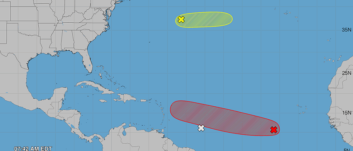
The National Hurricane Center is now monitoring three areas across the Atlantic basin Tuesday morning, but one system in the central tropical Atlantic continues to stand out from the others.
An area of low pressure approximately 500 miles southwest of the Cabo Verde Islands continues to have a 70% chance of tropical development during the next seven days, and a tropical depression will likely form later this week.
Meanwhile, two additional disturbances are being monitored across the Atlantic, although neither currently presents a significant development threat.
Central Atlantic System Remains the One to Watch
Shower and thunderstorm activity associated with the area of low pressure southwest of the Cabo Verde Islands is currently limited.
That doesn't necessarily indicate the system is becoming less likely to develop.
Environmental conditions are forecast to become increasingly favorable for organization during the next couple of days as the disturbance continues moving west to west-northwest across the central tropical Atlantic.
As of the 8 a.m. Tuesday Tropical Weather Outlook, development probabilities remain:
- Next 48 hours: 30%
- Next 7 days: 70%
The National Hurricane Center says a tropical depression will likely form during the latter half of this week.
This is the same system I've been following over the past several days as its development chances have gradually increased.
Still Much Too Early for U.S. Impacts
While development appears increasingly likely, there is an important distinction between forecasting tropical development and forecasting where a system will eventually go.
At this stage, the disturbance remains thousands of miles from the United States, and there is no reliable way to determine whether it will eventually threaten the East Coast, Gulf Coast or remain over the open Atlantic.
The immediate forecast calls for the system to move generally westward to west-northwestward across the central tropical Atlantic.
Where it goes beyond that will depend on the atmospheric steering pattern that develops during the coming days.
The important takeaway for Rowan County and North Carolina remains the same: this is a system to monitor, not a system to worry about at this point.
There is currently no specific threat to North Carolina.
Tropical Wave Approaching Windward Islands Unlikely to Develop
A second tropical disturbance is located approximately 600 miles east of the Windward Islands.
Disorganized showers and thunderstorms are accompanying the tropical wave as it moves toward the Lesser Antilles.
Unlike the central Atlantic disturbance, conditions ahead of this system are expected to become increasingly hostile for tropical development.
The wave is forecast to encounter a large area of dry air as it approaches the Windward Islands.
Development probabilities are:
- Next 48 hours: Near 0%
- Next 7 days: Near 0%
Although tropical development is not expected, the wave could still bring locally heavy rainfall and gusty winds to portions of the Lesser Antilles during the next couple of days.
That's an important reminder that a tropical disturbance doesn't need to become a named storm to produce periods of disruptive weather.
Third System Being Watched Northeast of Bermuda
The National Hurricane Center has also added an area in the central subtropical Atlantic to its outlook.
A trough of low pressure located several hundred miles northeast of Bermuda is producing showers and thunderstorms.
Some development is possible during the next day or so while the system moves eastward at approximately 20 mph.
Its development window will be short.
The disturbance is forecast to move over cooler ocean waters later this week, which should bring any opportunity for tropical formation to an end by Thursday.
Development probabilities are:
- Next 48 hours: 10%
- Next 7 days: 10%
Given its movement and the cooler waters ahead, this system currently appears considerably less likely to develop than the disturbance farther south in the tropical Atlantic.
Three Systems, But One Clear Focus
Seeing three areas highlighted simultaneously on a tropical outlook can make the Atlantic look particularly active, but the development probabilities help put the situation into perspective.
The tropical wave approaching the Windward Islands has essentially no development chance. The system northeast of Bermuda has only a brief and limited opportunity to organize.
That leaves the low southwest of the Cabo Verde Islands as the primary system I'll be following.
Its 70% seven-day development probability and the expectation that a tropical depression will likely form later this week make it the system that deserves the most attention.
For now, however, the focus is on whether a tropical depression actually develops and how quickly the system organizes.
Only after that occurs and the steering pattern becomes clearer will there be greater confidence regarding its longer-range track.
Rowan County Weather will continue monitoring the central Atlantic disturbance as it moves westward across the tropical Atlantic this week.