
Tuesday Could Bring More Than Typical Summer Thunderstorms to Rowan County
Tuesday could bring a different type of thunderstorm threat to Rowan County than the isolated summertime storms we have seen on many recent afternoons.
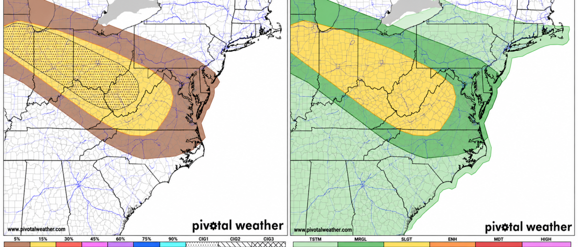
The Storm Prediction Center has placed Rowan County and a large portion of the region under a Marginal Risk for severe thunderstorms Tuesday, with the primary concern being damaging wind gusts.
While this is the lowest of the five severe weather risk categories, there are indications that thunderstorms Tuesday could become more organized than the typical isolated afternoon storms we see during August.
5% Damaging Wind Risk Includes Rowan County
The Storm Prediction Center's latest Day 2 outlook places Rowan County within an area where there is a 5% probability of damaging thunderstorm winds occurring within 25 miles of any given point.
That number can sometimes sound insignificant, but it is important to understand what it represents.
A 5% probability does not mean there is only a 5% chance of a thunderstorm occurring. Instead, it represents the probability of severe wind occurring within 25 miles of a location.
That is enough of a threat for the Storm Prediction Center to include Rowan County in its Marginal Risk area.
The more substantial severe weather probabilities are currently positioned northwest of Rowan County, extending from portions of the Ohio and Tennessee valleys toward the Appalachians.
How thunderstorms evolve as they move southeast will be important for our weather Tuesday.
An Organized Thunderstorm Complex Could Develop
One of the biggest questions involves the potential development of an organized complex of thunderstorms, commonly referred to as an MCS, or mesoscale convective system.
Rather than individual thunderstorms popping up randomly during the heat of the afternoon, an MCS can organize numerous thunderstorms into a much larger system capable of traveling hundreds of miles.
These systems can sometimes maintain their strength for hours and produce widespread strong winds along their path.
Forecast guidance suggests an organized thunderstorm complex could develop upstream and move generally southeast toward the Appalachians and Piedmont Tuesday.
There remains considerable uncertainty regarding its eventual track.
Some guidance favors a path farther north toward Virginia, while another possibility would bring storms or an associated outflow boundary farther south into northwestern North Carolina and potentially toward our area.
Small changes in the track could make a substantial difference in what Rowan County experiences.
Timing Could Be Late Tuesday
The current Rowan County forecast calls for a 30% chance of showers and thunderstorms developing mainly after 5 p.m. Tuesday.
Tuesday's high is expected to reach around 95 degrees, with heat index values potentially reaching 103 degrees.
That hot and humid air will provide plenty of instability for thunderstorms if a triggering mechanism reaches the area.
At this point, the most likely period to monitor appears to be late Tuesday afternoon into Tuesday evening.
The exact timing will depend heavily on how thunderstorms develop upstream and whether they can maintain their organization while approaching North Carolina.
Damaging Winds Would Be the Primary Concern
If organized thunderstorms reach Rowan County, damaging straight-line winds would be the primary severe weather concern.
Thunderstorms will have access to substantial instability Tuesday, and drier air in portions of the atmosphere could help stronger storms transport powerful winds toward the surface.
This does not mean widespread damaging winds are expected across Rowan County.
The current Marginal Risk and 5% damaging-wind probability indicate that the overall severe weather threat remains relatively low, but it is high enough that Tuesday deserves more attention than an ordinary summer afternoon.
Heavy rainfall and frequent lightning would also be possible with any stronger thunderstorms.
Wednesday May Need to Be Watched, Too
Tuesday may not be the end of the story.
The atmosphere could remain favorable for additional organized thunderstorm activity Wednesday as disturbances continue moving around the northern side of a strengthening upper-level ridge.
What happens Tuesday could have a significant influence on Wednesday's forecast.
Thunderstorm complexes frequently leave behind outflow boundaries and areas of cloud cover that can alter temperatures, instability and where the next round of thunderstorms develops.
Because of those smaller-scale factors, Wednesday's storm potential may not become clear until we see how Tuesday unfolds.
No Need to Sound the Alarm — But Tuesday Deserves Attention
There is an important distinction between having an environment capable of producing severe thunderstorms and knowing that severe thunderstorms will affect Rowan County.
At this point, we have the first of those.
Rowan County is under a Marginal Risk, with a 5% damaging-wind probability, but there remains considerable uncertainty surrounding storm coverage, timing and the track of any organized thunderstorm complex.
For now, Tuesday is a day to keep on the radar rather than a day to make major changes to plans.
As we get closer, shorter-range forecast models should provide a better picture of where thunderstorms develop and whether an organized complex will have an opportunity to reach Rowan County.
Rowan County Weather will continue monitoring the latest data today and Tuesday, with updates as the potential becomes clearer.