
Three Areas Being Monitored in Atlantic as Development Chances Increase
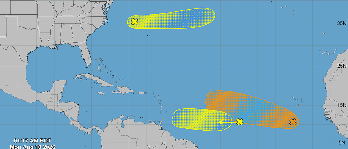
The Atlantic tropics are becoming more active as we move deeper into August, with three areas now being monitored for possible tropical development.
The area drawing the most attention is in the eastern and central tropical Atlantic, where conditions are expected to become increasingly favorable for development later this week. However, it remains far too early to determine whether this system will eventually pose any threat to the United States or the Carolinas.
Eastern and Central Tropical Atlantic — 60% Development Chance
A small area of low pressure located a few hundred miles south of the Cabo Verde Islands is currently producing disorganized showers and thunderstorms.
A tropical wave moving across western Africa is expected to merge with this area of low pressure within the next couple of days.
Environmental conditions are forecast to become more favorable for organization around the middle of the week. A tropical depression could form during the second half of the week as the system moves generally west to west-northwest across the central tropical Atlantic.
The probability of tropical development currently stands at:
- 20% during the next 48 hours
- 60% during the next seven days
This is the system that deserves the most attention over the coming days. Even if a tropical depression or tropical storm develops, however, there are many days of travel across the Atlantic ahead of it.
There is currently no reliable way to determine whether the system would eventually approach the Caribbean, turn north over the Atlantic or take another track entirely.
For Rowan County and the Carolinas, there is no immediate concern from this system. It is simply something worth monitoring as forecast confidence improves.
Central Tropical Atlantic — 10% Development Chance
A broad area of showers and thunderstorms associated with another tropical wave is located roughly midway between the western coast of Africa and the Lesser Antilles.
Some gradual development remains possible through the middle of the week as the wave moves quickly westward across the tropical Atlantic.
Conditions are then expected to become less favorable for development later in the week as the system approaches the Lesser Antilles.
The probability of tropical development is:
- 10% during the next 48 hours
- 10% during the next seven days
Unless conditions change considerably, development of this system currently appears unlikely.
Western Subtropical Atlantic — 10% Development Chance
A third area is being monitored several hundred miles northwest of Bermuda.
A trough of low pressure is producing disorganized showers and thunderstorms, and some limited development is possible during the next couple of days.
The system is expected to move quickly eastward across the western and central subtropical Atlantic, remaining well north of Bermuda.
By later this week, it should encounter cooler ocean waters that will become increasingly unfavorable for tropical development. Its opportunity for development is expected to end after Wednesday.
The probability of tropical development is:
- 10% during the next 48 hours
- 10% during the next seven days
Because this system is moving eastward over the open Atlantic, it currently poses no threat to the southeastern United States.
Atlantic Activity Beginning to Increase
August typically marks the beginning of a significant increase in tropical activity across the Atlantic Basin as ocean temperatures remain warm and atmospheric conditions become increasingly favorable.
The eastern and central tropical Atlantic will be the area to watch most closely this week.
A 60% development probability does not mean there is a 60% chance of the system affecting North Carolina. It only represents the probability that a tropical cyclone will form within the designated area during the next seven days.
Even if development occurs later this week, questions about its eventual strength and track would take considerably longer to answer.
For now, there are no tropical threats to Rowan County or the Carolinas from any of the three areas being monitored.
Rowan County Weather will continue monitoring activity across the Atlantic as we move through the heart of the 2026 hurricane season.