
Two Tropical Waves Now Being Monitored Across the Atlantic
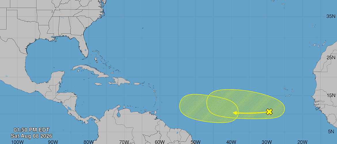
The National Hurricane Center is now monitoring two tropical waves across the Atlantic, including one system already moving across the central tropical Atlantic and another expected to emerge from the west coast of Africa next week.
As of 2 PM Saturday, August 8, both systems have a low chance of development over the next seven days.
Central Tropical Atlantic Wave
A tropical wave is currently located a few hundred miles southwest of the Cabo Verde Islands.
Some gradual development of this system is possible during the early to middle part of next week as it moves westward across the central tropical Atlantic.
The National Hurricane Center currently gives this system a near 0 percent chance of formation through the next 48 hours and a 20 percent chance of formation through the next seven days.
Conditions are not expected to remain favorable indefinitely. Upper-level winds are forecast to become much less supportive of development later in the week as the system approaches the Lesser Antilles.
That means any opportunity for organization may be limited to the first half of next week.
Another Tropical Wave Expected to Emerge From Africa
A second tropical wave is expected to move off the west coast of Africa on Tuesday.
This system could have some opportunity for development during the middle to latter part of next week as it tracks westward across the eastern and central tropical Atlantic.
Its chance of formation is near 0 percent through the next 48 hours and 30 percent through the next seven days.
That 30 percent chance is still considered low, but it represents an increase from the 20 percent chance assigned to this wave earlier Saturday.
No Threat to North Carolina at This Time
Neither of these systems poses any threat to North Carolina at this time.
Both are far out in the tropical Atlantic, and there is considerable uncertainty regarding whether either wave will organize into a tropical depression or tropical storm.
Even if development occurs, it would be far too early to determine any eventual impacts to the Caribbean, the United States, or North Carolina.
Long-range tropical forecasts can change significantly from one model run to the next, especially when dealing with systems that do not yet have a defined circulation.
What to Watch Next
The first wave will need to organize before upper-level winds become less favorable later in the week.
The second wave may have a somewhat better opportunity for development after it moves off Africa, but confidence remains low at this stage.
The most important things to watch over the next several days will be whether thunderstorm activity becomes more persistent, whether a defined circulation begins to form, and whether development probabilities continue to increase.
Atlantic Basin Becoming More Active
It is not unusual to see more tropical waves being monitored as August progresses.
This is the time of year when the tropical Atlantic typically becomes increasingly active and waves moving off Africa become more important to watch.
That does not mean either of these systems will become a significant storm, but their presence is a reminder that hurricane season is moving deeper into its more active portion.
Rowan County Weather will continue monitoring both tropical waves and provide updates as new information becomes available.