
Tropical Wave Expected to Emerge Off Africa Next Week, Development Possible
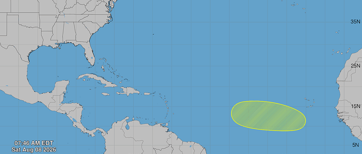
The National Hurricane Center is monitoring the eastern tropical Atlantic for the potential development of a new tropical system during the middle to latter part of next week.
As of Saturday morning, August 8, a tropical wave is expected to move off the west coast of Africa on Tuesday. Once the wave moves over the Atlantic Ocean, environmental conditions could allow for some gradual development as it tracks westward across the eastern and central tropical Atlantic.
Development Not Expected in the Short Term
There is no immediate development expected from this system.
The chance of tropical cyclone formation through the next 48 hours is near 0 percent.
The National Hurricane Center currently gives the system a 20 percent chance of development during the next seven days.
That keeps the development potential in the "low" category.
A Long Way From the United States
This system will initially be thousands of miles away from the United States as it emerges from Africa and moves across the open tropical Atlantic.
At this stage, it is far too early to determine whether the tropical wave will eventually organize into a tropical depression or tropical storm, much less whether it could pose any threat to the United States.
The system will need to survive its journey across the tropical Atlantic, and its future will depend on several factors including atmospheric moisture, wind shear, sea surface temperatures, and the overall steering pattern.
Long-range model guidance can change significantly with systems that have not yet moved over water or developed a defined circulation.
Why This Area Is Worth Watching in August
The tropical Atlantic typically becomes more active as August progresses.
Waves regularly move westward from Africa during this part of hurricane season, and some of the stronger Atlantic hurricanes in history have originated from tropical waves that developed in this region.
That does not mean this particular wave will become a significant storm. A 20 percent development chance means there is still a much greater chance that a tropical cyclone will not form during the next seven days.
However, the system is worth monitoring as it moves over the Atlantic next week.
No Threat to North Carolina at This Time
There is currently no tropical threat to North Carolina from this system.
Even if development eventually occurs, it would take many days for the system to cross the Atlantic, and there is no reliable way at this point to determine its eventual track or strength.
Residents should be cautious about social media posts showing long-range model projections of a hurricane approaching the United States. Individual model runs this far in advance can change dramatically and should not be treated as forecasts.
The more important information over the next several days will be whether the tropical wave actually begins organizing after it moves off Africa.
Rowan County Weather Will Continue Monitoring the Tropics
Rowan County Weather will continue monitoring this tropical wave as it emerges into the Atlantic and provide updates if the chances for development increase.
For now, there is no reason for concern locally. This is simply an area to watch as we move deeper into the heart of the Atlantic hurricane season.