

Strong to Severe Thunderstorms Possible Tuesday Across Rowan, Davie, and Davidson Counties
Published: Monday, August 3, 2026
An unsettled weather pattern will continue across the Carolinas on Tuesday, bringing an increased chance for showers and thunderstorms to Rowan, Davie, and Davidson counties. While not everyone will experience severe weather, a few storms could become strong to severe during the afternoon and evening.
The Storm Prediction Center has placed Rowan, Davie, and Davidson counties under a Marginal Risk (Level 1 of 5) for severe thunderstorms on Tuesday. The primary severe weather hazard will be isolated damaging wind gusts, with a 5% wind risk across the area. In addition, slow-moving storms will be capable of producing very heavy rainfall that could lead to localized flooding.
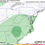
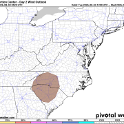
Forecast guidance shows showers and thunderstorms becoming more numerous during the afternoon before continuing into the evening. An upper-level low moving across the Southeast will provide the lift needed for storm development while deep tropical moisture remains in place across the region.
Primary Hazards
Damaging Wind
- An isolated severe thunderstorm could produce wind gusts capable of downing tree limbs and causing isolated power outages.
- The Storm Prediction Center's 5% wind risk indicates that a few storms may become strong enough to produce damaging wind gusts.
Heavy Rainfall
- Storms will be capable of producing torrential rainfall in a short period of time.
- Slow-moving thunderstorms and repeated rounds of rain may result in localized flooding, especially in poor drainage and low-lying areas.
- Rainfall rates could become intense under the strongest storms.
Frequent Lightning
- Every thunderstorm will produce dangerous cloud-to-ground lightning.
- If you can hear thunder, you are close enough to be struck by lightning and should move indoors immediately.
While widespread severe weather is not expected, any stronger storm could quickly produce hazardous conditions.
Timing
The greatest chance for showers and thunderstorms will be Tuesday afternoon through Tuesday evening, although a few showers may develop earlier in the day. Storm coverage is expected to increase during the afternoon as daytime heating combines with abundant moisture and the approaching upper-level disturbance.
Forecast Overview
Rowan County
- Tuesday: Showers and thunderstorms become likely during the afternoon and evening. High near 81°.
- Tuesday Night: Showers and thunderstorms remain likely before gradually diminishing overnight. Low around 66°.
Davie County
- Tuesday: Showers and thunderstorms become likely during the afternoon and evening. High near 81°.
- Tuesday Night: Showers and thunderstorms remain likely through much of the night. Low around 68°.
Davidson County
- Tuesday: Showers and thunderstorms become likely during the afternoon and evening. High near 81°.
- Tuesday Night: Showers and thunderstorms remain likely before gradually decreasing late. Low around 68°.
Stay Weather Aware
Residents across Rowan, Davie, and Davidson counties should monitor the forecast throughout the day Tuesday, especially if you have outdoor plans. Have multiple ways to receive weather warnings, and be prepared to move indoors immediately if thunderstorms approach.
In addition to the isolated severe weather threat, everyone should remain alert for heavy rainfall that could produce localized flooding. Never drive through flooded roadways, as water depth and road conditions can be difficult to judge.
Rowan County Weather will continue to monitor conditions and provide updates if stronger storms begin to develop Tuesday.