

Wet Weather Returns This Weekend; Marginal Risk for Severe Storms on Sunday
SALISBURY, N.C. — After a mainly dry and warm Saturday, the weather pattern will become much more active across Rowan, Davie, and Davidson Counties beginning tonight and continuing through Sunday.
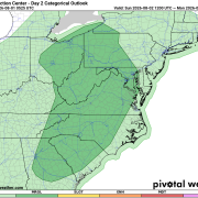
The Storm Prediction Center has placed all three counties under a Marginal Risk (Level 1 of 5) for severe thunderstorms on Sunday. While widespread severe weather is not expected, a few storms could become strong enough to produce isolated damaging wind gusts.
In addition to the severe weather risk, the atmosphere will contain an unusually high amount of moisture. This will allow thunderstorms to produce torrential rainfall, increasing the potential for localized flooding, especially in areas where storms repeatedly move over the same locations.
Saturday: Dry for Most, Storms Late
Most of Saturday will be dry with a mix of sun and clouds and afternoon highs reaching the mid-80s.
A few isolated showers or thunderstorms may develop late this afternoon, but the better chance for widespread rain arrives this evening and overnight as a frontal system approaches from the west.
Sunday: Wettest Day of the Forecast
Sunday is expected to bring numerous showers and thunderstorms throughout the day, with periods of heavy rainfall possible.
Several rounds of showers and thunderstorms may move across the area, and some storms could repeatedly track over the same locations. This "training" effect could quickly produce several inches of rain in isolated areas, resulting in localized flooding of roads, poor drainage areas, and low-lying locations.
Marginal Risk for Severe Weather
While heavy rainfall is the primary concern, a few thunderstorms may also become strong.
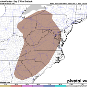
The Storm Prediction Center has outlined Rowan, Davie, and Davidson Counties in a Marginal Risk (Level 1 of 5) for severe weather on Sunday, including a 5% probability of damaging wind gusts within 25 miles of any given location.
The overall severe weather threat remains low, but a stronger storm could produce:
- Wind gusts over 40 mph
- Frequent cloud-to-ground lightning
- Torrential rainfall
- Localized flooding
Large hail and tornadoes are not expected to be the primary threats.
Looking Ahead
The unsettled weather pattern doesn't end Sunday. Daily chances for showers and thunderstorms will continue into much of next week, especially during the afternoon and evening hours.
Temperatures will remain seasonable with highs generally in the lower to middle 80s, which is slightly below normal for early August.
Residents with outdoor plans this weekend should keep a close eye on the forecast and be prepared to move indoors quickly if thunderstorms develop. Heavy rainfall and lightning will pose the greatest hazards through Sunday.