

Strong to Severe Thunderstorms Possible Tuesday Across Rowan, Davie, and Davidson Counties
A more active weather pattern is expected to develop on Tuesday as a cold front approaches the Carolinas, bringing the potential for strong to severe thunderstorms across Rowan, Davie, and Davidson counties.
The Storm Prediction Center (SPC) has placed all three counties under a Slight Risk (Level 2 of 5) for severe thunderstorms. While not everyone will experience severe weather, conditions are favorable for scattered storms capable of producing damaging winds and large hail.
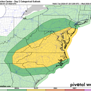
Damaging Winds Are the Primary Concern
The greatest threat with any storms that develop Tuesday afternoon and evening will be damaging straight-line wind gusts.
The SPC has outlined our area in a 30% probability for damaging winds, indicating a higher-than-average chance that some storms could produce winds strong enough to knock down trees, damage power lines, and cause scattered power outages.
Residents should be prepared for rapidly changing weather if thunderstorms develop.
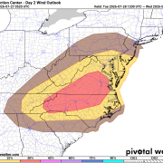
Large Hail Also Possible
In addition to the wind threat, the SPC has highlighted our area with a 15% probability for severe hail.
While widespread hail is not expected, the strongest thunderstorms could produce hail up to around one inch in diameter, which is large enough to damage vehicles, roofs, and outdoor property.
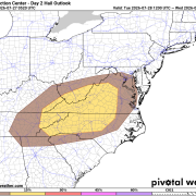
Timing
Storm development is expected during the Tuesday afternoon and evening hours, generally after 2 PM and continuing into the evening as the cold front moves through the region.
Not every community will receive a thunderstorm, but those that do could experience hazardous weather in a short period of time.
Forecast Confidence
There is still some uncertainty regarding how widespread the storms will become.
Morning clouds or leftover showers from upstream thunderstorms could limit daytime heating and reduce instability. If that happens, the severe threat would be somewhat lower. However, if the atmosphere becomes sufficiently unstable Tuesday afternoon, storms could quickly intensify as the cold front approaches.
We'll continue to monitor forecast trends as newer data becomes available.
What You Should Do Today
Now is a good time to prepare before storms arrive:
- Review your severe weather safety plan.
- Make sure you have multiple ways to receive weather warnings Tuesday afternoon and evening.
- Secure loose outdoor items that could be blown around by strong winds.
- Stay tuned to Rowan County Weather for forecast updates as confidence in storm timing and impacts improves.
After the cold front moves through Tuesday night, sunshine, lower humidity, and more comfortable temperatures are expected to return Wednesday and continue through the end of the workweek.