

Strong to Severe Thunderstorms Possible Tuesday as Cold Front Approaches
After a relatively quiet weather pattern through Monday, attention is turning to Tuesday, when the potential for strong to severe thunderstorms will increase across central North Carolina.
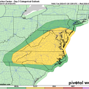
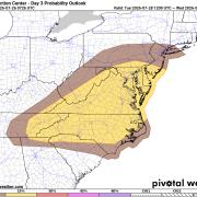
The Storm Prediction Center has placed much of the Carolinas, including Rowan, Davie, and Davidson counties, in a Slight Risk (Level 2 of 5) for severe thunderstorms on Tuesday. This means scattered severe storms are possible, and some could become capable of producing damaging weather.
Why Tuesday Looks Different
Monday should remain mostly dry with only isolated storm chances, but the atmosphere will begin changing as warmer temperatures, increasing humidity, and a cold front approach from the northwest.
By Tuesday afternoon, temperatures are expected to climb into the lower 90s, while heat index values may approach or exceed 100°. That warm, humid air will provide plenty of fuel for thunderstorm development as the front moves into the region.
At the same time, winds higher in the atmosphere will strengthen, allowing storms to organize more efficiently than we've seen recently.
Main Threats
At this time, the greatest concern appears to be:
- Damaging straight-line wind gusts
- Torrential rainfall and localized flooding
- Isolated large hail
- A brief tornado cannot be ruled out, although the overall tornado threat currently appears lower than the wind threat.
Timing
Current indications suggest storms will begin developing Tuesday afternoon, with the greatest coverage and strongest storms expected late Tuesday afternoon through Tuesday evening as the cold front moves across the area.
The exact timing will become clearer over the next 24 to 36 hours.
Forecast Confidence
Confidence is increasing that thunderstorms will develop Tuesday, and confidence is also increasing that at least some storms could become severe.
However, several details still need to be resolved, including:
- Exactly when storms develop.
- Whether morning clouds or leftover showers affect afternoon instability.
- Whether storms arrive as a broken line or individual cells.
These factors will determine how widespread the severe weather threat ultimately becomes.
Improving Weather Follows
Once the cold front moves through Tuesday night, a much more comfortable air mass arrives.
Expect:
- Plenty of sunshine Wednesday and Thursday.
- Highs settling back into the mid to upper 80s.
- Noticeably lower humidity with dew points dropping into the lower 60s, making it feel much more comfortable outside.
Rowan County Weather will continue monitoring this evolving forecast.
While Tuesday is not expected to be an all-day severe weather event, it is shaping up to be the most active weather day of the upcoming week. Be sure to check back for forecast updates as confidence continues to increase and the timing becomes more refined.