

Slight Risk for Severe Storms and Flash Flooding Today Across Central North Carolina
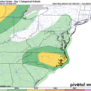
An active weather pattern will continue across central North Carolina today, and portions of our area are included in the Storm Prediction Center's Slight Risk (Level 2 of 5) for severe thunderstorms.
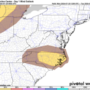
The greatest concern will be damaging wind gusts from strong thunderstorms, although torrential rainfall could also lead to localized flash flooding, especially where storms repeatedly move over the same locations.
Who Is Included?
Davidson County
- The entire county is under a Slight Risk (Level 2 of 5) for severe thunderstorms.
- Davidson County is also within the 15% damaging wind risk, indicating a higher potential for storms capable of producing wind gusts of 58 mph or greater.
Rowan County
- Eastern portions of Rowan County are included in the Slight Risk.
- Eastern Rowan is also within the 15% damaging wind probability, while the remainder of the county remains in the Marginal Risk area.
Davie County
- Eastern Davie County is included in the Slight Risk and the 15% damaging wind risk.
- Western portions of the county remain in the Marginal Risk.
Timing
Storms are expected to begin developing during the mid to late afternoon, becoming more numerous through the evening before gradually diminishing overnight.
Main Threats
Damaging wind gusts up to 60 mph or higher
Torrential rainfall that could cause localized flash flooding
Frequent cloud-to-ground lightning
Downed trees and isolated power outages
Stay Weather Aware
While not everyone will experience severe weather, any thunderstorm that develops this afternoon and evening could become strong quickly. If you have outdoor plans, make sure you have multiple ways to receive weather warnings and be prepared to move indoors if storms approach.
I'll be monitoring conditions throughout the day and will provide radar updates and any watches or warnings as they are issued.
#RowanCounty #DavieCounty #DavidsonCounty #NCwx #SevereWeather #FlashFlooding #Thunderstorms