

Weekend Cold Front Brings Better Rain Chances to Rowan County
After several days of hot, mostly dry weather, the pattern is set to become more active this weekend as a cold front approaches the Carolinas.
The front will bring increasing chances for showers and thunderstorms Saturday and Sunday, along with a slight drop in temperatures by early next week. While not everyone will see rain, many communities across Rowan County have a much better opportunity to receive beneficial rainfall than they have in recent days.
Hot Weather Holds On Through Saturday
The weekend will begin with one more day of intense summer heat.
Friday's high will reach 97 degrees, followed by another hot day Saturday with highs around 94 degrees. Heat index values will climb into the 100 to 102-degree range each afternoon.
Although temperatures will ease slightly on Sunday, highs near 91 degrees combined with higher humidity will continue to make it feel uncomfortable outdoors.
Storm Chances Increase This Weekend
Saturday will start with a mix of sunshine and increasing clouds before scattered thunderstorms begin developing during the afternoon.
Current forecast highlights include:
- Saturday: 50% chance of showers and thunderstorms, mainly between 3 PM and 5 PM.
- Saturday Night: 60% chance of showers and thunderstorms during the evening.
- Sunday: 60% chance of showers and thunderstorms, with activity becoming more widespread during the late afternoon and evening.
- Sunday Night: 70% chance of showers and thunderstorms before gradually decreasing overnight.
The best opportunity for widespread rainfall currently appears to be Sunday into Sunday evening, when the approaching cold front moves into the region.
Sunday Could Bring Strong to Severe Storms
Sunday is shaping up to be the most active weather day of the weekend.
The Storm Prediction Center has placed all of Rowan County under a Slight Risk (Level 2 of 5) for severe thunderstorms on Sunday. A Slight Risk means scattered severe thunderstorms are possible, with atmospheric conditions becoming more favorable for organized storms than we typically see during the summer.
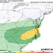
The approaching cold front will combine with hot, humid air already in place across the Carolinas to create an environment capable of producing stronger thunderstorms during the late afternoon and evening.
The primary threats include:
- Damaging straight-line wind gusts
- Frequent cloud-to-ground lightning
- Torrential downpours that could lead to localized flooding
- Small hail cannot be ruled out
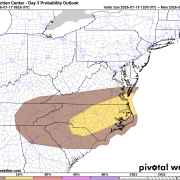
At this time, damaging wind gusts appear to be the greatest concern. While not everyone in Rowan County will experience severe weather, everyone should remain weather aware and have multiple ways to receive warnings, especially if you have outdoor plans Sunday afternoon or evening.
Forecast timing currently favors the greatest storm potential from late Sunday afternoon through Sunday evening, although that timing could shift somewhat as newer forecast data becomes available.
This is one of the higher severe weather outlooks we've seen for Rowan County in several weeks and will be monitored closely as the weekend approaches.
Will This Help the Drought?
The weekend rainfall is certainly welcome, but it's unlikely to erase the ongoing drought.
Many locations could pick up beneficial rainfall from one or more thunderstorms, while others may receive much less depending on exactly where storms develop. Summer thunderstorms often produce highly variable rainfall totals, with one community receiving over an inch while another nearby receives very little.
Even so, the increased rain chances are encouraging and should provide some relief for lawns, gardens, streams, and agricultural interests.
Looking Ahead
Behind the cold front, temperatures will ease slightly early next week.
- Monday: High near 88° with a 30% chance of afternoon showers and thunderstorms.
- Tuesday: Mostly sunny with a high near 92° and lower rain chances.
While this won't be a major cool down, it will provide a welcome break from the upper 90s experienced over the past several days.
Residents should continue practicing heat safety through Saturday while also preparing for a more active weather pattern this weekend. Stay hydrated during the afternoon heat, and if thunderstorms approach, head indoors immediately. Rowan County Weather will continue to monitor the latest forecast trends and provide updates as confidence in Sunday's severe weather potential increases.