

Weekend Cold Front Brings Better Rain Chances to Rowan County
After several days of intense summer heat, changes are finally on the way. While Friday will likely be the hottest day of the week, a cold front approaching from the north will bring increasing chances for showers and thunderstorms across Rowan County this weekend, along with slightly cooler temperatures early next week.
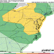
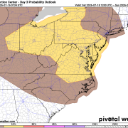
The Storm Prediction Center has placed Rowan County under a Level 1 of 5 (Marginal Risk) for severe thunderstorms on Saturday. A Marginal Risk indicates that isolated severe thunderstorms are possible, with the greatest concern being localized damaging wind gusts. The accompanying probability outlook also places Rowan County in a 5% severe weather risk, meaning there's about a 5% chance of severe weather occurring within 25 miles of any given location. While widespread severe weather is not expected, a few stronger storms cannot be ruled out.
As we move through Friday, an upper-level ridge responsible for the recent stretch of hot weather will remain in control. Afternoon temperatures are expected to climb into the mid to upper 90s, with heat index values reaching between 100 and 105 degrees. Aside from an isolated afternoon thunderstorm, most communities should remain dry through Friday.
The pattern begins to change on Saturday.
A cold front will gradually sink south toward the Carolinas while the upper ridge weakens. At the same time, abundant Gulf and Atlantic moisture will stream northward into the region, creating a much more favorable environment for scattered showers and thunderstorms.
Most of Saturday will not be a washout. In fact, much of the morning and early afternoon should remain dry with partly to mostly sunny skies. By mid to late afternoon, thunderstorms are expected to develop and become more numerous through the evening and into Saturday night.
A few of the stronger storms could produce:
- Wind gusts capable of bringing down small tree limbs
- Frequent cloud-to-ground lightning
- Torrential downpours
- Localized flooding in poor drainage and low-lying areas
The unsettled weather pattern continues into Sunday as the cold front lingers nearby. Additional scattered afternoon and evening thunderstorms are expected before activity gradually returns to a more typical summertime pattern early next week.
The good news is that temperatures will become a little more manageable. Highs are expected to fall from the upper 90s on Friday to the lower 90s on Sunday and around 90 degrees by Monday. While still warm, the combination of slightly lower temperatures and more cloud cover will make conditions feel less oppressive than they have over the past several days.
For those planning to attend Farmers Day in China Grove, Friday evening currently looks very favorable for outdoor activities. While an isolated shower or thunderstorm can't be completely ruled out, most of the area should remain dry. Saturday is a different story. Much of the morning and early afternoon should be rain-free, but the chance for showers and thunderstorms will increase later in the afternoon and continue into the evening. If you're heading to Farmers Day on Saturday, it's a good idea to stay weather aware and have a way to receive weather updates. As a reminder, Rowan County Weather is not the official weather partner for Farmers Day and does not make decisions regarding event operations or cancellations. Always follow guidance from Farmers Day organizers regarding any schedule changes due to weather.
Although the current outlook suggests only an isolated severe weather threat for Rowan County, Saturday will be the day to monitor most closely. Forecast confidence will continue to improve over the next couple of days, and the timing and strength of any thunderstorms will become clearer as the weekend approaches.
If you have outdoor plans Saturday afternoon or evening, it's a good idea to keep an eye on the forecast and have a way to receive weather warnings. As always, I'll continue to monitor the latest forecast trends and provide updates if the severe weather risk changes.