Davie County Forecast: Friday Heat Gives Way to Increasing Weekend Storm Chances
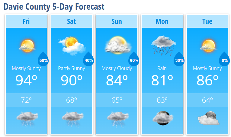
Hot and humid weather continues across Davie County through Saturday, but the forecast turns more active as we head into the weekend. While Friday will feature only isolated afternoon and evening thunderstorms, rain chances increase Saturday and peak Sunday as a cold front approaches.
Behind that front, much cooler air arrives early next week, bringing a welcome break from the summer heat.
Friday
Expect mostly sunny skies and another hot afternoon with a high near 94°. Heat index values will make it feel even warmer, so take plenty of breaks and stay hydrated if you'll be outdoors. A 30% chance of showers and thunderstorms develops after 2 PM. A few storms could become strong with damaging wind gusts.
Friday Night
Scattered showers and thunderstorms remain possible through the evening before gradually diminishing overnight. Mostly cloudy skies with a low around 72°.
Saturday
Partly sunny skies will allow temperatures to climb to around 90° before scattered showers and thunderstorms develop during the afternoon. Rain chances increase to 40%, with a few stronger storms capable of producing gusty winds.
Saturday Night
A few showers and thunderstorms may continue into the evening before tapering off overnight. Low temperatures fall to around 68°.
Sunday
Sunday brings the best opportunity for widespread rainfall. Mostly cloudy skies are expected with a high near 84°. Showers become more numerous during the afternoon, with thunderstorms likely after 4 PM. Rain chances climb to 60%, and locally heavy rainfall will be possible.
Sunday Night
Showers and thunderstorms remain likely through the evening before gradually decreasing overnight. Low temperatures settle near 65°.
Monday
A few lingering showers remain possible through early afternoon before conditions improve. Expect partly sunny skies with a high near 81°, making it one of the coolest days in several weeks.
Monday Night
Mostly cloudy with a low around 63°.
Tuesday
Mostly sunny and pleasant with a high near 86°.
What Has Changed?
- The Storm Prediction Center has expanded the Marginal Risk (Level 1 of 5) for severe thunderstorms into the area for Friday, signaling a slightly better chance for a few strong to severe storms.
- Sunday continues to look like the wettest day of the forecast as a cold front moves through the region.
Key Messages
- Friday remains hot with highs in the mid-90s.
- A few thunderstorms Friday and Saturday could produce damaging wind gusts.
- Rain and thunderstorm coverage increases through the weekend, with the best chance for widespread rain arriving Sunday.
- Locally heavy rainfall may become a concern Sunday into early next week.
- Cooler weather arrives Monday, with highs dropping into the lower 80s before temperatures gradually rebound later next week.