Davidson County Forecast: Hot Through Saturday, Cooler Air Arrives Early Next Week
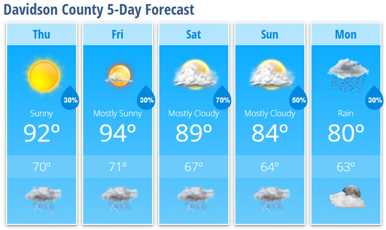
Summer heat will continue across Davidson County through Saturday, with afternoon highs climbing into the lower to middle 90s. While only isolated afternoon and evening thunderstorms are expected today and Friday, a much wetter pattern develops this weekend as a cold front approaches.
That front will bring increasing chances for showers and thunderstorms Saturday and Sunday, followed by a refreshing break from the heat. By Monday, afternoon temperatures will only reach around 80°, making for a much more comfortable start to next week.
Today
Expect plenty of sunshine and another hot afternoon. Highs will reach around 92° with a light west wind developing during the afternoon. A 30% chance of showers and thunderstorms develops after 5 PM, but many communities will remain dry.
Tonight
Any isolated evening storms will end after sunset, leaving partly cloudy skies overnight. Low temperatures will fall to around 70°.
Friday
Another hot summer day is expected with mostly sunny skies and a high near 94°. There is a 30% chance of showers and thunderstorms during the mid to late afternoon, mainly between 3 PM and 5 PM.
Friday Night
A slight chance of an evening shower or thunderstorm lingers before skies gradually become mostly cloudy. Low temperatures settle near 71°.
Saturday
Clouds increase as a cold front approaches from the north. High temperatures reach around 89°, with showers and thunderstorms becoming much more likely during the afternoon. Rain chances increase to 70%, especially after 2 PM.
Saturday Night
Showers and thunderstorms remain likely through the evening before gradually tapering overnight. Low temperatures fall to around 67°.
Sunday
Mostly cloudy skies continue with scattered showers and thunderstorms possible throughout the day. High temperatures will be noticeably cooler, reaching around 84°. Rain chances remain at 50%.
Sunday Night
A few showers and thunderstorms may linger into the evening before ending overnight. Low temperatures will dip to around 64°.
Monday
Cooler air settles across Davidson County. There remains a 30% chance of a lingering shower through early afternoon, otherwise expect partly sunny skies with a high near 80°.
What Has Changed?
- No major changes for Davidson County.
- Heat Advisories remain confined to portions of the southern Coastal Plain and do not include Davidson County.
Key Messages
- Hot and humid conditions continue through Saturday with highs in the lower to middle 90s.
- Isolated afternoon and evening thunderstorms remain possible today and Friday.
- A few stronger storms could produce damaging wind gusts, especially Friday and Saturday.
- Shower and thunderstorm coverage increases significantly this weekend as a cold front moves through.
- Much cooler air arrives Sunday into early next week, with highs falling to around 80° by Monday.