Davie County Forecast: Summer Heat Continues Through Saturday, Cooler Air Arrives for the End of the Weekend
Good evening! Typical July weather continues across Davie County through Saturday with warm afternoons, increasing humidity, and the daily chance for pop-up thunderstorms. A cold front this weekend will bring higher rain chances before ushering in cooler temperatures for Sunday and Monday.
Thursday
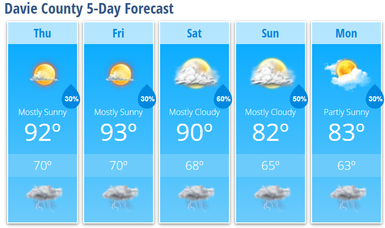
Expect mostly sunny skies with a high near 92°. A 30% chance of showers and thunderstorms develops after 5 PM, although many locations will remain dry. Any storm that forms could produce gusty winds, frequent lightning, and brief heavy rainfall.
Thursday night will be mostly clear with a lingering 30% chance of a thunderstorm before 8 PM before conditions quiet down. Overnight lows will fall to around 70°.
Friday
Friday brings another warm summer day with mostly sunny skies and a high near 93°. A 30% chance of showers and thunderstorms returns after 4 PM, with most of the activity remaining isolated.
Friday night stays mostly cloudy with a slight chance of an evening thunderstorm and a low around 70°.
Weekend Forecast
Saturday marks the beginning of a wetter weather pattern.
High temperatures will top out near 90°, while shower and thunderstorm chances increase throughout the afternoon. Rain becomes more likely after 4 PM, with a 60% chance of showers and thunderstorms continuing into Saturday night.
Some storms could become strong, with damaging wind gusts remaining the primary severe weather threat.
Cooler Air Arrives
The cold front begins moving through on Sunday, bringing noticeably cooler temperatures.
- Sunday: Mostly cloudy with a high near 82° and a 50% chance of showers and thunderstorms.
- Monday: Partly sunny with a high near 83° and a 30% chance of showers and thunderstorms.
This cooler pattern should provide a welcome break after several days of above-normal temperatures.
What I'm Watching
- Hot, humid afternoons continue through Saturday, with highs in the lower 90s.
- Isolated afternoon and evening thunderstorms remain possible Thursday and Friday, with damaging wind gusts the primary concern in stronger storms.
- Rain chances increase significantly Saturday afternoon through Sunday as a cold front approaches.
- Cooler temperatures arrive for Sunday and Monday, with highs settling into the lower 80s and noticeably more comfortable conditions.
If you have outdoor plans over the next few days, be sure to stay hydrated, take breaks from the heat, and keep an eye on the sky during the afternoon hours. I'll continue tracking storm development and provide updates if stronger storms move toward Davie County.