Davidson County Forecast: Summer Heat Holds On, Better Storm Chances Return This Weekend
The hot and humid weather pattern continues across Davidson County through the end of the workweek. Afternoon temperatures will remain in the 90s with isolated thunderstorms developing during the late afternoon and evening. A cold front is still expected to arrive this weekend, bringing increased rain chances and a welcome break from the heat by Sunday.
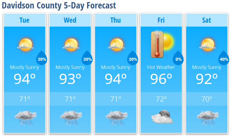
Today's Forecast
Another warm and humid summer day is ahead.
- High: 94°
- Rain Chance: 30% after 5 PM
- Wind: Calm becoming southwest around 5 mph
Scattered thunderstorms may develop late this afternoon and evening. Most locations will remain dry, but any storm that develops could produce heavy rain, gusty winds, and dangerous lightning.
Tonight
Storms gradually diminish after sunset.
- Low: 71°
- Rain Chance: 30% before 10 PM
Wednesday
A very similar weather day is expected.
- Mostly sunny
- High: 93°
- 30% chance of afternoon thunderstorms
- 30% chance of storms Wednesday night
Thursday
Hot weather continues.
- Mostly sunny
- High: 94°
- 30% chance of afternoon and evening thunderstorms
Friday
The hottest day of the forecast.
- Sunny
- High: 96°
- Dry for most of the county
Saturday
Storm chances begin increasing ahead of an approaching cold front.
- Mostly sunny
- High: 92°
- 40% chance of afternoon thunderstorms
- 30% chance of storms Saturday night
What I'm Watching
Hot Weather Continues
High temperatures will remain in the lower to middle 90s through Friday, creating uncomfortable conditions during the afternoon. While Davidson County is expected to stay just below widespread heat advisory criteria, it will still be important to take heat precautions if you're spending time outdoors.
✔ Drink plenty of water.
✔ Take frequent breaks in the shade or air conditioning.
✔ Never leave children or pets in a parked vehicle.
Daily Thunderstorm Chances
Scattered afternoon and evening thunderstorms will remain possible each day, with coverage increasing this weekend as a cold front approaches.
Any stronger storm could produce:
- Damaging wind gusts
- Frequent lightning
- Brief heavy rainfall with localized flooding in poor drainage areas
Cooler Air Arrives Sunday
The weekend cold front should bring a noticeable drop in humidity along with temperatures easing back into the upper 80s and lower 90s by Sunday and early next week, making for a much more comfortable stretch of weather.
Davidson County Weather Summary
- Hot afternoons continue through Friday.
- Daily afternoon and evening thunderstorm chances remain in the forecast.
- A few storms could become strong with gusty winds and heavy rainfall.
- Rain chances increase Saturday as a cold front approaches.
- Cooler and less humid weather is expected to arrive beginning Sunday.