Rowan County Forecast: Summer Heat Continues, Limited Storm Chances Through the Week
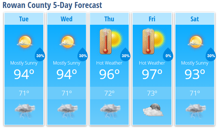
The hot and humid stretch isn't going anywhere just yet. Afternoon highs will remain in the mid to upper 90s through the end of the workweek, with heat index values climbing into the lower 100s during the hottest part of each afternoon. While a pop-up thunderstorm can't be ruled out each day, many neighborhoods will stay dry until a cold front arrives this weekend.
Today's Forecast
Expect mostly sunny skies and another hot afternoon.
- High: 94°
- Heat Index: Up to 102°
- Rain Chance: 30% after 5 PM
- Wind: Calm becoming west-southwest around 6 mph
A few isolated thunderstorms may develop late this afternoon and evening. Not everyone will see rain, but any storm that forms could produce brief heavy downpours, gusty winds, and lightning.
Tonight
Any storms should diminish by around 10 PM, leaving partly cloudy skies overnight.
- Low: 71°
- Rain Chance: 30% before 10 PM
Wednesday
Another day that looks very similar to today.
- Mostly sunny
- High: 94°
- Heat Index: Around 102°
- 30% chance of an evening thunderstorm
Thursday
The heat turns up another notch.
- Mostly sunny and hot
- High: 96°
- 30% chance of late afternoon and evening thunderstorms
Friday
The hottest day of the forecast.
- Sunny and very hot
- High: 97°
- Dry for most locations
Saturday
A cold front begins approaching from the northwest.
- Mostly sunny
- High: 93°
- 30% chance of afternoon and evening thunderstorms
Storm coverage should become a little more widespread this weekend as the front approaches.
What I'm Watching
Heat Remains the Main Story
Heat index values will reach 100-102° each afternoon through at least Saturday. While this is expected to stay just below Heat Advisory criteria, it will still be dangerous for anyone spending extended time outdoors.
✔ Stay hydrated.
✔ Take frequent breaks in air conditioning or shade.
✔ Never leave children or pets inside unattended vehicles.
Isolated Strong Storms Possible
Most afternoons will feature only isolated thunderstorms, but any storm that develops could become strong.
The primary concern will be:
- Damaging wind gusts
- Frequent lightning
- Brief heavy rainfall
Storm coverage should increase over the weekend as a cold front moves into the Carolinas.
Relief Is On The Way
The good news is that this prolonged stretch of heat should finally begin easing by Sunday into early next week. Temperatures are expected to fall back into the upper 80s and lower 90s, with noticeably lower humidity making it feel much more comfortable.
Rowan County Weather Summary
- Hot afternoons continue through Saturday.
- Heat index values around 100-102° each day.
- Isolated afternoon and evening storms remain possible daily.
- Any stronger storm could produce damaging wind gusts.
- Cooler and less humid air is expected to arrive beginning Sunday.