Rowan County Forecast: Summer Heat Continues with Isolated Storm Chances Through the Week
Hot and humid weather remains locked in across Rowan County through the remainder of the workweek. Afternoon temperatures will continue reaching the lower to middle 90s, with heat index values climbing to around 102 degrees on Tuesday.
While most days won't be complete washouts, isolated to scattered afternoon and evening thunderstorms remain in the forecast each day. The greatest storm coverage is expected over the North Carolina mountains, but a few storms could drift into the Piedmont during the late afternoon and evening. A couple of storms could become strong, with damaging wind gusts remaining the primary threat.
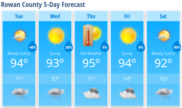
Tuesday
Expect increasing clouds through the day with another hot and humid afternoon.
- High: 94°
- Heat Index: Up to 102°
- Rain Chance: 30%, mainly after 5 PM
- Wind: Calm becoming west-southwest around 6 mph
Any storms that develop could produce brief heavy rainfall, gusty winds, and dangerous lightning.
Tuesday Night
A few showers and thunderstorms remain possible during the evening before skies gradually clear overnight.
- Low: 71°
- Rain Chance: 40%, mainly before 10 PM
Wednesday
Mostly sunny with another warm afternoon and only a slight chance of a late-day thunderstorm.
- High: 93°
- Rain Chance: 20%
Thursday
Mostly sunny and hot.
- High: 95°
A stray afternoon thunderstorm can't be ruled out, but many locations should remain dry.
Friday
Summer heat continues.
- High: 94°
Expect another warm and humid day with only isolated afternoon storm chances.
Saturday
Storm chances increase as a cold front approaches the region.
- High: 92°
- Rain Chance: 50%
Scattered showers and thunderstorms become more likely during the afternoon and evening.
Weather Discussion
The overall weather pattern changes very little through the week. Warm, humid air will continue flowing into the Carolinas while a stalled cold front remains well to our north. This will keep temperatures above normal while providing enough moisture for daily afternoon thunderstorm development.
Although the middle of the week may feel slightly less oppressive, with highs generally in the low to mid-90s and somewhat lower humidity, summer heat quickly builds again by the end of the week as the Bermuda High strengthens over the western Atlantic.
Each afternoon, scattered thunderstorms may develop with daytime heating. While many communities will stay dry, any storm that forms could briefly become strong. Damaging wind gusts remain the primary severe weather concern, along with frequent lightning and locally heavy rainfall.
Forecast confidence decreases later in the week, but several upper-level disturbances and an approaching cold front could bring a more organized round of showers and thunderstorms on Saturday. Behind the front, temperatures and humidity are expected to ease somewhat heading into next week.
Rowan County Weather Summary
- Highs remain in the lower to middle 90s through Friday.
- Heat index values around 100–102° Tuesday, with hotter conditions returning late week.
- Daily afternoon and evening thunderstorm chances continue.
- A few storms each afternoon could produce damaging wind gusts.
- Better rain chances arrive Saturday as a cold front approaches, followed by slightly cooler and less humid air.