Davie County Forecast: Hot Summer Weather Continues with Daily Storm Chances
Hot and humid weather will continue across Davie County through the workweek as temperatures climb into the middle 90s each afternoon. Heat index values will reach 100 to 103 degrees, making it feel even hotter during the peak of the day.
Daily afternoon and evening thunderstorms remain part of the forecast, with today offering the best opportunity for scattered storms. A few storms could become strong, producing damaging wind gusts, heavy downpours, and frequent lightning. Storm coverage becomes a little more isolated from Wednesday through Friday before increasing again next weekend as a cold front approaches.
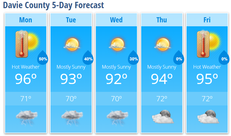
Today's Forecast
Expect patchy morning fog to give way to mostly sunny, hot, and humid conditions.
- High: 96°
- Heat Index: Up to 103°
- Rain Chance: 30%, mainly after 5 PM
- Wind: Light and variable
Any storms that develop late this afternoon or evening could produce locally heavy rainfall and strong wind gusts.
Tonight
Scattered showers and thunderstorms continue into the evening before tapering off overnight. Patchy fog may develop late tonight.
- Low: 71°
- Rain Chance: 50%
Tuesday
Another hot summer day with sunshine for much of the day before isolated afternoon thunderstorms develop.
- High: 93°
- Heat Index: Around 100°
- Rain Chance: 40%, mainly between 3 PM and 5 PM
Tuesday Night
A few showers and thunderstorms remain possible during the late evening and overnight hours.
- Low: 70°
- Rain Chance: 40%
Wednesday
Mostly sunny with only a slight chance of a late-day thunderstorm.
- High: 92°
- Rain Chance: 20%
Thursday
Mostly sunny and hot.
- High: 94°
Friday
Sunny skies continue with midsummer heat.
- High: 95°
Weather Discussion
A persistent Bermuda High will continue pumping warm, humid air into the Carolinas through the week. Afternoon temperatures will remain 4 to 8 degrees above normal, while overnight lows stay warm and muggy in the lower 70s.
Although heat index values may climb above 100 degrees, they are expected to remain just below Heat Advisory criteria. Even so, anyone spending extended time outdoors should stay hydrated, take frequent breaks in the shade or air conditioning, and avoid strenuous outdoor activities during the hottest part of the afternoon.
Today's atmosphere will once again support scattered thunderstorms during the afternoon and evening. Some storms could become strong enough to produce damaging wind gusts, so it's important to have multiple ways to receive weather warnings if you'll be outdoors.
From Wednesday through Friday, storm chances become a bit lower as high pressure strengthens, although isolated afternoon storms will still be possible. Forecast confidence increases that another cold front will move toward the region this weekend, bringing a better chance of showers and thunderstorms back to Davie County.
Davie County Weather Summary
- Highs remain in the lower to middle 90s through Friday.
- Heat index values between 100° and 103° each afternoon.
- Daily afternoon and evening thunderstorm chances continue.
- A few storms today could produce damaging wind gusts.
- Storm chances decrease slightly midweek before increasing again next weekend.