Rowan County Forecast: Hot Summer Pattern Continues with Isolated Storm Chances
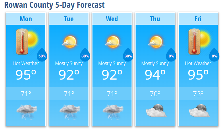
The hot and humid summer pattern remains firmly in place across Rowan County this week. Afternoon highs will stay in the lower to middle 90s through Friday, with heat index values reaching around 100 degrees at times. While each day won't be a washout, isolated to scattered afternoon and evening thunderstorms will remain possible, especially today and Tuesday.
Today's storms could become strong with gusty, damaging winds as the primary threat. As the week progresses, storm coverage should become a bit more isolated before another weather system approaches next weekend.
Today's Forecast
Expect mostly sunny skies with hot and humid conditions.
- High: 95°
- Heat Index: Up to 100°
- Rain Chance: 30%, mainly after 5 PM
- Wind: Calm becoming south-southwest around 6 mph
Any thunderstorms that develop late this afternoon and evening could produce brief heavy rain, lightning, and strong wind gusts.
Tonight
Scattered showers and thunderstorms remain possible through around 1 AM before activity diminishes overnight.
- Low: 71°
- Rain Chance: 50%
Tuesday
Another hot day with sunshine dominating much of the day before isolated afternoon thunderstorms develop.
- High: 92°
- Rain Chance: 30%, mainly after 4 PM
Tuesday Night
A few evening storms remain possible before skies gradually become partly cloudy overnight.
- Low: 71°
- Rain Chance: 30%
Wednesday
Another typical summer day with plenty of sunshine and only a slight chance of a late-day thunderstorm.
- High: 92°
- Rain Chance: 20%
Thursday
Mostly sunny and hot.
- High: 94°
Friday
Summer heat continues heading into the weekend.
- High: 95°
Weather Discussion
Heat and humidity will continue to be the biggest story through the workweek. Afternoon temperatures in the 90s combined with muggy conditions will make it feel close to 100 degrees during the hottest part of the day.
While heat advisory criteria are not expected to be reached, anyone spending time outdoors should:
- Stay well hydrated.
- Take frequent breaks in the shade or air conditioning.
- Never leave children or pets inside parked vehicles, where temperatures can become deadly within minutes.
Today's atmosphere will once again support scattered afternoon and evening thunderstorms. A few storms may become strong enough to produce damaging wind gusts, so be sure to have multiple ways to receive weather warnings if you'll be outside later today.
Storm coverage becomes a little more limited from Wednesday through Friday, although a few afternoon storms remain possible each day. Another cold front is expected to approach next weekend, likely bringing a better chance for showers and thunderstorms across the area.
Rowan County Weather Summary
- Highs remain in the lower to middle 90s all week.
- Heat index values near 100° during the afternoons.
- Daily afternoon and evening storm chances continue.
- A few storms today could produce damaging wind gusts.
- Storm coverage decreases midweek before increasing again next weekend.