Davidson County Forecast: Hot Summer Weather Continues with Daily Storm Chances
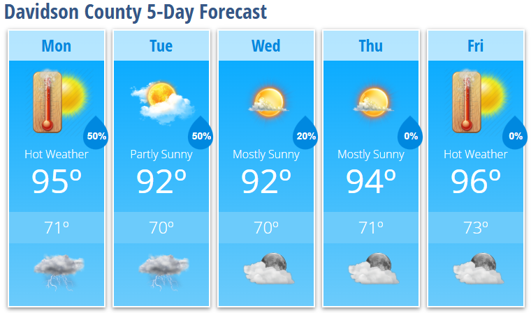
Davidson County will remain in a classic summertime weather pattern through the workweek. Expect hot afternoons, warm and muggy nights, and daily opportunities for showers and thunderstorms, although temperatures will continue to trend slightly lower than they were during the peak of last week's heat wave.
Monday: Hot with Only Isolated Afternoon Storms
Monday will feature mostly sunny skies and another hot afternoon.
High temperatures will reach 95 degrees, while the heat index climbs to around 100 degrees.
Most of the day should remain dry before a few showers and thunderstorms develop during the late afternoon and evening.
Monday night brings a 50% chance of showers and thunderstorms, mainly before 1 AM.
Tuesday: Another Active Afternoon
Tuesday will be another warm and humid day with highs near 92 degrees.
Scattered showers and thunderstorms are expected to develop after 2 PM, with a 50% chance of rain through the afternoon and evening.
While widespread severe weather is not expected, a few stronger storms could produce:
- Gusty to locally damaging wind gusts
- Frequent lightning
- Heavy downpours
- Localized flooding in poor drainage areas
Midweek Brings a Slight Break
Storm coverage becomes a little more isolated on Wednesday.
Wednesday's forecast includes:
- Mostly sunny skies
- High near 92 degrees
- Only a 20% chance of an afternoon thunderstorm
Thursday looks mainly dry with sunshine and highs climbing back to 94 degrees.
Heat Builds Again Late Week
Friday will be the warmest day of the week with plenty of sunshine and highs reaching 96 degrees.
Even though the extreme heat has eased somewhat, afternoons will still feel uncomfortable, and overnight lows will only fall into the lower 70s.
Looking Ahead
The overall weather pattern remains active through the week.
Daily afternoon thunderstorms remain possible, but forecasters are also watching several weather disturbances that could increase shower and thunderstorm coverage later this week and into next weekend.
With a more favorable wind pattern developing aloft, some storms later this week could become more organized than the typical summertime "pop-up" thunderstorms.
Bottom Line
- High temperatures remain in the lower to middle 90s all week.
- Heat index values will approach 100 degrees each afternoon.
- Daily afternoon and evening thunderstorms remain in the forecast.
- A few storms could produce gusty to damaging winds and heavy rainfall.
- An increasingly active weather pattern may develop later this week and into next weekend.
If you'll be spending time outdoors this week, continue practicing heat safety, stay hydrated, and keep an eye on the sky during the afternoon and evening hours. Summer thunderstorms can develop quickly, and I'll continue monitoring conditions and providing updates throughout the week.