Davidson County Forecast: Heat Continues as Storm Chances Increase Early This Week
The hottest days of this recent heat wave are behind us, but Davidson County will remain hot and humid through the week. Afternoon temperatures will stay in the lower to middle 90s, while shower and thunderstorm chances increase Monday and Tuesday before returning to a more typical summertime pattern later in the week.
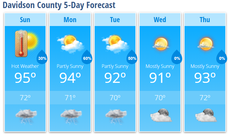
Today's Forecast
Expect mostly sunny skies and another hot afternoon with temperatures climbing to 95°.
A few showers and thunderstorms may develop after 2 PM, but many communities will stay dry. Any storm that does form could produce gusty winds, frequent lightning, heavy downpours, and localized flooding.
- High: 95°
- Rain Chance: 30%
- Wind: South around 5 mph
Tonight
A few showers and thunderstorms may linger into the evening before gradually ending overnight. Skies become partly cloudy with another warm and muggy night.
- Low: 72°
- Rain Chance: 30%
Monday
Storm coverage increases as a weak weather system approaches the region.
Showers and thunderstorms become likely during the afternoon and evening, with some storms capable of producing heavy rainfall, gusty winds, and dangerous lightning.
- High: 94°
- Rain Chance: 60%
Monday Night
Showers and thunderstorms remain likely through the evening before gradually tapering off after midnight.
- Low: 71°
- Rain Chance: 60%
Tuesday
Another warm and humid day with scattered afternoon and evening thunderstorms.
- High: 92°
- Rain Chance: 50%
Wednesday
Mostly sunny with a return to more isolated afternoon storm chances.
- High: 91°
- Low: 70°
Thursday
Mostly sunny and warm.
- High: 93°
- Low: 72°
What I'm Watching
While temperatures are trending a few degrees lower than the peak of the recent heat wave, it will still feel very uncomfortable outdoors through the first half of the week.
The greatest weather concern shifts from the heat to increasing thunderstorm coverage Monday and Tuesday. Some storms may produce localized flooding from heavy rainfall, damaging wind gusts, frequent lightning, and brief torrential downpours. Rain won't be continuous, but periods of heavy rain are possible where storms repeatedly move over the same locations.
By the middle and latter part of the week, thunderstorm coverage should become more scattered and typical of summertime before another increase in rain chances next weekend.
Heat Safety
Even though temperatures are a little lower than earlier this week, it will still be dangerous for anyone spending extended time outdoors.
- Stay hydrated throughout the day.
- Take frequent breaks in the shade or air conditioning.
- Never leave children or pets inside a parked vehicle.
- Have multiple ways to receive weather warnings if you'll be outside during the afternoon or evening.
Overall, expect continued heat and humidity with the most widespread thunderstorm chances arriving Monday and Tuesday, followed by a more typical summertime weather pattern during the second half of the week.