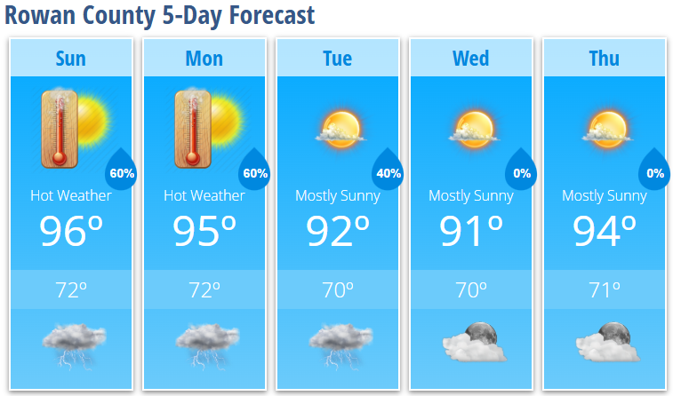
Rowan County Forecast: Heat Continues, Daily Storm Chances Return
After a brief break from the extreme heat, Rowan County is settling into a more typical July weather pattern. Afternoon temperatures will remain in the middle 90s each day, with heat index values reaching around 100 degrees, while scattered afternoon and evening thunderstorms become a daily possibility through at least Tuesday.
Today's Forecast
Expect increasing clouds through the afternoon with highs reaching 96°. Heat index values will climb to around 100°, making it feel even hotter.
A few showers and thunderstorms may develop after 2 PM, with storm coverage increasing after 4 PM. Any storm will be capable of producing brief heavy rainfall, frequent lightning, gusty winds, and localized downpours.
- High: 96°
- Heat Index: Around 100°
- Rain Chance: 60%
- Wind: South around 6 mph
Tonight
Showers and thunderstorms will remain likely through the evening before gradually ending around or shortly after midnight. Skies become partly cloudy overnight with another warm and muggy night.
- Low: 72°
- Rain Chance: 60%
Monday
Another hot and humid afternoon is expected with highs near 95° and heat index values around 100°.
Most of the day will remain dry before another round of showers and thunderstorms develops late in the afternoon and evening.
- High: 95°
- Rain Chance: 40% during the afternoon, increasing Monday evening.
Monday Night
Showers and thunderstorms become likely before tapering off around midnight.
- Low: 72°
- Rain Chance: 60%
Tuesday
Temperatures ease back just a bit, but it will remain hot with highs near 92°. Afternoon thunderstorms are again possible, and a few could become stronger than previous days.
- High: 92°
- Rain Chance: 30%
Wednesday
Mostly sunny with slightly lower humidity behind a weak front.
- High: 91°
- Low: 70°
Thursday
Heat begins building again with mostly sunny skies.
- High: 94°
- Low: 71°
What I'm Watching
The weather pattern shifts into a classic summertime setup this week. While the extreme heat from recent days is easing slightly, temperatures will continue running well above normal with warm, humid nights.
The greatest concern each afternoon will be scattered thunderstorms. Most storms will remain hit-or-miss, but any that develop could quickly become strong with damaging wind gusts from collapsing storms, frequent lightning, and torrential rainfall. Tuesday currently appears to have the best potential for a few stronger storms as a weak cold front approaches.
Heat Safety
Even without a Heat Advisory, conditions will still be dangerous for anyone spending extended time outdoors.
- Stay hydrated throughout the day.
- Take frequent breaks in air conditioning or the shade.
- Never leave children or pets inside a parked vehicle, even for a few minutes.
- Have multiple ways to receive weather warnings if you'll be outdoors during the afternoon or evening.
Overall, expect a hot, humid week with daily opportunities for afternoon and evening thunderstorms, especially through Tuesday, before storm coverage becomes a little more isolated during the second half of the week.