Rowan County Forecast: Heat Begins to Ease, But Storm Chances Increase This Week
The prolonged stretch of dangerous holiday heat is beginning to ease, but don't expect a dramatic cooldown just yet. While temperatures will gradually trend downward through the upcoming week, humidity will remain high and afternoon and evening thunderstorms will become much more common.
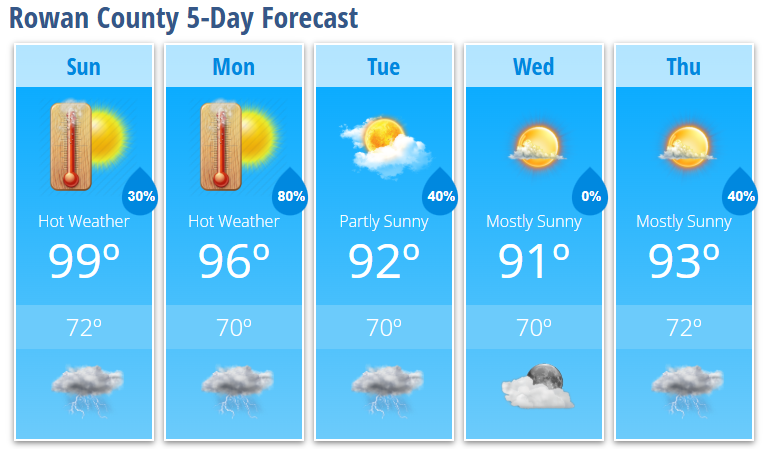
Sunday will still be another hot day with highs approaching 99° and heat index values reaching 103°. Most of the day will stay dry, but scattered thunderstorms are expected to develop during the late afternoon and evening. Any storm could produce heavy rainfall, frequent lightning, and gusty winds.
Monday brings the best opportunity for widespread rainfall as showers and thunderstorms become likely during the afternoon and evening. Temperatures will continue to cool into the lower 90s by midweek, bringing more typical July weather to Rowan County.
Day-by-Day Forecast
Sunday: Mostly sunny and hot with a high near 99°. Heat index values up to 103°. A 30% chance of late afternoon and evening showers and thunderstorms.
Sunday Night: Partly cloudy with a 30% chance of showers and thunderstorms around midnight. Low near 72°.
Monday: A chance of showers during the afternoon, becoming likely after 4 PM. High near 96° with heat index values around 102°. 80% chance of rain.
Monday Night: Showers and thunderstorms likely before 11 PM. Mostly cloudy with a low around 70°.
Tuesday: Partly sunny with a high near 92°. A 30% chance of afternoon thunderstorms.
Tuesday Night: Mostly cloudy with a 40% chance of showers and thunderstorms. Low near 70°.
Wednesday: Mostly sunny with a high near 91°.
Wednesday Night: Partly cloudy with a low around 70°.
Thursday: Mostly sunny with a high near 93°. A 40% chance of afternoon thunderstorms.
What Has Changed?
- No significant changes have been made to the forecast.
- The transition to a more active summertime weather pattern remains on track.
- Monday continues to look like the wettest day of the upcoming week.
Rowan County Weather Summary
The worst of the holiday heat is coming to an end, but it will still be hot Sunday with heat index values exceeding 100°. Beginning Sunday afternoon, daily chances for showers and thunderstorms return as a more typical summer weather pattern develops. Monday currently offers the highest chance for widespread rain, with scattered afternoon and evening storms remaining possible through the rest of the week. While temperatures gradually fall back into the lower 90s, humidity will remain elevated, making it feel muggy outdoors.