Davie County Forecast: Dangerous Heat Continues Through the Holiday Weekend, Storm Chances Increase Next Week
Published: Friday Evening, July 3, 2026
Dangerous heat will continue across Davie County through the Independence Day weekend, with another Heat Advisory in effect for Saturday from Noon until 8:00 PM. While sunny skies will continue through the weekend, a more typical summer weather pattern returns early next week as afternoon and evening thunderstorm chances increase.
Independence Day Forecast
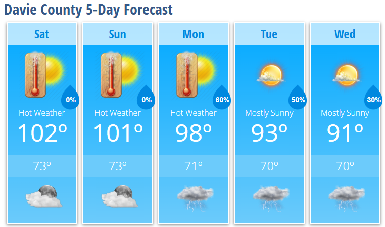
Saturday will be another dangerously hot day with abundant sunshine and a high near 102°. Even with slightly lower humidity during the afternoon, it will still feel as hot as 105°.
A Heat Advisory will be in effect from Noon until 8:00 PM, so anyone attending parades, cookouts, or fireworks displays should plan for dangerous heat.
Saturday night will remain mostly clear and warm with a low around 73°.
Sunday
Sunday brings another day of intense summer heat with mostly sunny skies and a high near 101°.
The forecast is now expected to remain dry through Sunday night, with mostly clear skies continuing overnight and temperatures falling to around 73°.
Although no Heat Advisory has been issued for Sunday yet, heat index values are expected to remain in the triple digits, and additional heat headlines may become necessary.
Looking Ahead
The prolonged heat slowly eases next week, although temperatures will remain above normal.
Rain and thunderstorm chances increase as deeper moisture returns to the region.
- Monday: Mostly sunny and hot with a high near 98°. Showers and thunderstorms become likely after 5 PM with a 60% chance of rain.
- Tuesday: Mostly sunny with a high near 93°. A 50% chance of afternoon and evening thunderstorms.
- Wednesday: Mostly sunny with a high near 91°. A 30% chance of afternoon and evening thunderstorms.
A few storms next week could become strong, with damaging wind gusts being the primary threat.
Forecast Highlights
- Heat Advisory in effect Saturday from Noon until 8 PM.
- High temperatures around 102° Saturday and 101° Sunday.
- Heat index values will reach 105° Saturday afternoon.
- Independence Day remains dry for outdoor celebrations and fireworks.
- Thunderstorm chances increase beginning Monday.
- A few storms next week could produce damaging wind gusts.
Heat Safety
If you'll be outdoors this holiday weekend:
- Drink plenty of water throughout the day.
- Take regular breaks in the shade or air conditioning.
- Wear lightweight, light-colored clothing.
- Avoid strenuous activities during the hottest part of the afternoon.
- Never leave children or pets inside a parked vehicle.
- Check on elderly relatives, neighbors, and anyone without reliable air conditioning.
After several consecutive days of dangerous heat, the risk of heat-related illnesses increases significantly, even for healthy individuals.
Davie County Weather Summary
The holiday weekend remains favorable for outdoor Fourth of July celebrations, with hot, sunny, and dry weather expected through Sunday. Dangerous heat continues to be the primary concern before a more typical summertime pattern returns next week with increasing chances for afternoon and evening thunderstorms and gradually cooler temperatures.