Davidson County Forecast: Dangerous Heat Continues Through the Fourth of July Weekend
Published: Friday, July 3, 2026
Dangerous heat will continue across Davidson County through the Independence Day weekend as temperatures remain near or above 100 degrees each afternoon. Heat index values will climb as high as 106°, creating hazardous conditions for anyone spending extended time outdoors.
While the holiday weekend will remain mostly dry, scattered showers and thunderstorms are expected to make a return beginning Sunday night, with higher rain chances continuing into early next week.
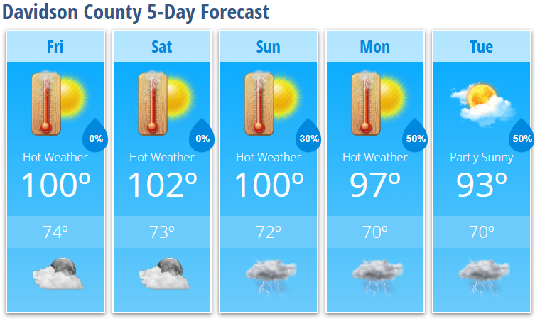
Today's Forecast (Friday)
Expect sunny skies and dangerous heat with a high near 100°. Combined with the humidity, it will feel as hot as 106° during the afternoon. Winds will remain light, becoming southeast around 5 mph later today.
Tonight will be mostly clear and warm with a low around 74°.
Independence Day Forecast (Saturday)
Independence Day will be another extremely hot day with abundant sunshine. High temperatures will reach around 102°, while the heat index climbs to 106°.
If you're planning to attend parades, cookouts, or fireworks displays, make heat safety part of your plans by staying hydrated, taking frequent breaks in the shade or air conditioning, and limiting strenuous activity during the hottest part of the day.
Saturday night will remain mostly clear with a low around 73°.
Sunday
Little change is expected with mostly sunny skies and another hot afternoon. High temperatures will reach around 100°.
A 30% chance of showers and thunderstorms develops Sunday evening before ending overnight.
Looking Ahead
The prolonged heat slowly begins to ease next week, but temperatures will remain above normal.
- Monday: Mostly sunny and hot with a high near 97°. A 50% chance of afternoon and evening showers and thunderstorms.
- Tuesday: Partly sunny with a high near 93°. A 50% chance of afternoon and evening showers and thunderstorms.
Forecast Highlights
- Dangerous heat continues through the Independence Day weekend.
- Heat index values will reach 106° both Friday and Saturday.
- Most Fourth of July celebrations should remain dry.
- Thunderstorm chances increase Sunday night and continue Monday and Tuesday.
- A few storms next week could produce locally damaging wind gusts.
Heat Safety
If you'll be outdoors this holiday weekend:
- Drink plenty of water throughout the day.
- Take frequent breaks in air-conditioned buildings or shaded areas.
- Wear lightweight, light-colored clothing.
- Never leave children or pets inside a parked vehicle.
- Check on elderly neighbors, family members, and anyone without adequate cooling.
Several consecutive days of dangerous heat can significantly increase the risk of heat-related illnesses. Even overnight temperatures will remain warm, limiting recovery from the daytime heat.
Davidson County Weather Summary
Dangerous heat remains the primary weather concern through the holiday weekend, with highs near or above 100 degrees and heat index values around 106°. Most outdoor Fourth of July activities should stay dry, but shower and thunderstorm chances return Sunday night and become more widespread Monday and Tuesday as the prolonged heat gradually begins to ease.