Davie County Forecast: Dangerous Heat Continues Through the Fourth of July Weekend
Published: Friday, July 3, 2026
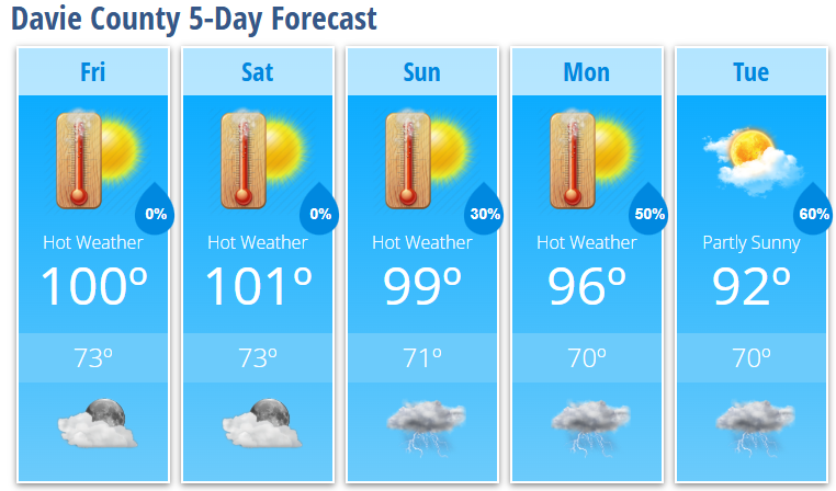
A prolonged stretch of dangerous summer heat will continue across Davie County through the Independence Day weekend. Afternoon temperatures will climb to around 100 degrees each day, while heat index values between 104° and 106° will make it feel even hotter.
The good news is that the holiday weekend looks mostly dry, providing favorable weather for outdoor celebrations and fireworks. However, everyone with outdoor plans should take the heat seriously. Scattered afternoon and evening thunderstorms become more likely beginning Sunday night and continue into next week.
Today's Forecast (Friday)
Expect sunny skies and dangerous heat with a high near 100°. Humidity will push the heat index as high as 106° during the afternoon. Winds will remain light and variable.
Tonight will be mostly clear and warm with a low around 73°.
Independence Day Forecast (Saturday)
The Fourth of July will bring another day of abundant sunshine and dangerous heat. High temperatures will reach around 101°, with heat index values climbing to 104°.
Whether you're attending parades, cookouts, or fireworks, be sure to drink plenty of water, take breaks in the shade, and avoid prolonged periods of strenuous activity during the hottest part of the afternoon.
Saturday night remains mostly clear with a low around 73°.
Sunday
Sunday stays hot with mostly sunny skies and a high near 99°.
A 30% chance of showers and thunderstorms develops Sunday evening, mainly before midnight.
Looking Ahead
The intense heat begins to ease slightly next week, although temperatures will remain well above average.
- Monday: Mostly sunny and hot with a high near 96°. A 30% chance of afternoon thunderstorms.
- Tuesday: Partly sunny with a high near 92°. A 60% chance of showers and thunderstorms during the afternoon and evening.
Forecast Highlights
- Dangerous heat continues through the Independence Day weekend.
- Heat index values will reach 104° to 106° each afternoon.
- Most Fourth of July celebrations should remain dry.
- Shower and thunderstorm chances increase Sunday night and continue into next week.
- Some storms next week could produce isolated damaging wind gusts.
Heat Safety
If you'll be spending time outdoors this holiday weekend:
- Drink water frequently, even if you don't feel thirsty.
- Take regular breaks in air-conditioned buildings or shaded locations.
- Wear lightweight, light-colored clothing.
- Never leave children or pets inside a parked vehicle.
- Check on elderly neighbors, family members, and anyone without reliable air conditioning.
Several consecutive days of dangerous heat increase the risk of heat-related illness. Plan outdoor activities during the morning or evening whenever possible.
Davie County Weather Summary
The holiday weekend forecast remains on track with dangerous heat and very limited rain chances through Sunday. Temperatures remain near or above 100 degrees before a gradual cooling trend begins next week. Afternoon and evening thunderstorms return beginning Sunday night, offering some localized relief from the prolonged heat.