Rowan County Forecast: Dangerous Heat Continues Through the Holiday Weekend
Dangerous summer heat will continue to build across Rowan County through the Fourth of July holiday weekend before a more typical summer weather pattern returns early next week.
Afternoon temperatures will climb into the upper 90s through Saturday, with heat index values reaching or exceeding 100 degrees. While widespread Heat Advisories are not expected at this time, the prolonged stretch of hot weather will still increase the risk of heat-related illnesses, especially for anyone spending extended time outdoors.
The good news is that relief is finally in sight. Beginning Sunday, temperatures should ease slightly as daily shower and thunderstorm chances return.
Forecast
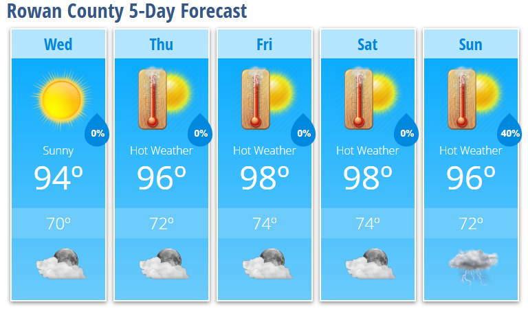
Wednesday
Sunny with a high near 94°. Calm wind.
Wednesday Night
Mostly clear with a low around 70°.
Thursday
Sunny and hot with a high near 96°. Heat index values as high as 100°. Light southeast wind during the afternoon.
Thursday Night
Mostly clear with a low around 72°.
Friday
Sunny and hot with a high near 98°.
Friday Night
Mostly clear with a low around 74°.
Independence Day (Saturday)
Sunny and hot with a high near 98°.
Saturday Night
Partly cloudy with a low around 74°.
Sunday
A 40% chance of afternoon showers and thunderstorms after 2 PM. Mostly sunny and hot with a high near 96°.
Sunday Night
A 40% chance of showers and thunderstorms. Mostly cloudy with a low around 72°.
Heat Remains the Main Story
A strong area of high pressure will remain centered over the southern Appalachians through the holiday weekend, producing one of the hottest stretches of weather so far this summer.
Afternoon temperatures will climb into the upper 90s while heat index values reach 100 degrees or higher during the hottest part of the day.
Although humidity is expected to mix out somewhat during the afternoon, the air temperatures alone will be enough to create dangerous conditions for anyone spending long periods outside.
If you're planning to attend fireworks displays, community events, sporting events, or cookouts, remember to:
- Stay well hydrated.
- Take frequent breaks in the shade or air conditioning.
- Wear lightweight, light-colored clothing.
- Never leave children or pets inside a parked vehicle.
- Check on elderly neighbors and those without reliable air conditioning.
A Pattern Change Arrives Sunday
Confidence continues to increase that the prolonged heat will begin easing late this weekend.
By Sunday, the ridge responsible for the hot weather will weaken and shift east, allowing a more typical July weather pattern to return.
That means:
- Afternoon temperatures return to the lower and middle 90s.
- Daily shower and thunderstorm chances increase.
- More typical summertime humidity returns.
- Locally heavy rain, gusty winds, and small hail will once again become possible in stronger storms.
While temperatures will remain warm, they should be much closer to average for early July.
Looking Ahead
The Fourth of July holiday itself still looks hot and dry across Rowan County, making for excellent weather for fireworks and outdoor celebrations—provided you take precautions against the heat.
Beginning Sunday and continuing into early next week, keep an eye on the forecast as scattered afternoon and evening thunderstorms become a daily possibility once again.