Davidson County Forecast: Dangerous Heat Builds Through the Fourth of July Weekend
A prolonged stretch of hot summer weather is on the way for Davidson County, with temperatures climbing well into the 90s through the Independence Day holiday weekend. While humidity won't be extreme, heat index values will still top 100 degrees during the afternoon, creating an elevated risk for heat-related illnesses.
No Heat Advisories have been issued at this time, but several consecutive days of intense heat can still be dangerous, especially for anyone spending extended periods outdoors.
Forecast
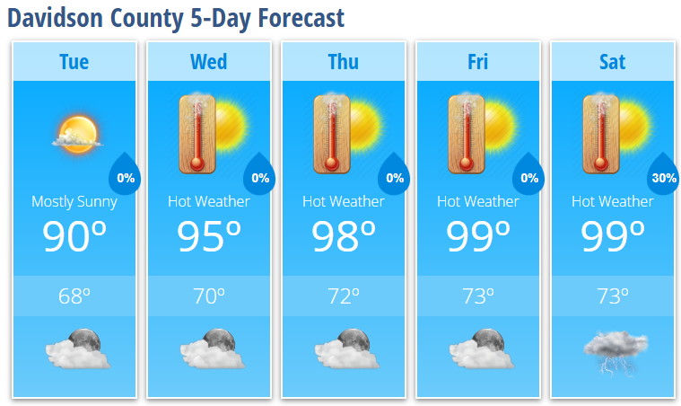
Tuesday
Mostly sunny with a high near 90°. Light east wind.
Tuesday Night
Partly cloudy with a low around 68°.
Wednesday
Sunny with a high near 95°. Heat index values as high as 101°.
Wednesday Night
Mostly clear with a low around 70°.
Thursday
Sunny and hot with a high near 98°.
Thursday Night
Mostly clear with a low around 72°.
Friday
Sunny and hot with a high near 99°.
Friday Night
Mostly clear with a low around 73°.
Independence Day (Saturday)
Sunny and hot with a high near 99°.
Saturday Night
A 30% chance of showers and thunderstorms before 2:00 AM. Partly cloudy with a low around 73°.
Heat Continues to Build
A strong area of high pressure will strengthen over the Tennessee Valley before shifting toward the Mid-Atlantic later this week. This pattern will allow temperatures to steadily increase across Davidson County through the Fourth of July weekend.
Highs will climb into the mid-90s Wednesday, upper 90s Thursday, and near 100 degrees Friday and Saturday. Heat index values will generally reach 100 to 103 degrees, making it feel even hotter during the afternoon.
Although forecast humidity levels are not expected to be high enough for widespread Heat Advisories, several days of prolonged heat can still have serious impacts, especially for those attending outdoor events, fireworks, cookouts, or sporting activities.
If you're spending time outside:
- Drink plenty of water throughout the day.
- Take frequent breaks in the shade or air conditioning.
- Wear lightweight, light-colored clothing.
- Know the signs of heat exhaustion and heat stroke.
- Never leave children or pets inside a parked vehicle.
Rain Chances Increase Late Weekend
Most of the holiday weekend will remain dry under the influence of the high-pressure ridge. A 30% chance of showers and thunderstorms arrives Saturday night as the ridge begins to weaken.
Rain and thunderstorm chances are expected to become more widespread Sunday and Monday, which should help bring temperatures down slightly heading into next week.
Near-Record Heat Possible
Temperatures this week will approach early July records across central North Carolina. While Davidson County may not set new records, highs in the upper 90s will make for one of the hottest stretches of weather so far this summer.
Whether you're traveling, grilling, heading to the lake, or enjoying fireworks, be prepared for dangerous heat and take steps to stay cool throughout the holiday weekend.