Davidson County Forecast: Dangerous Heat Builds Through the Fourth of July Weekend
A significant summer heat wave is on track for Davidson County as a strong area of high pressure continues to strengthen over the eastern United States.
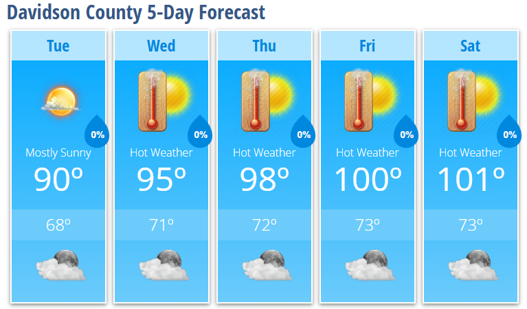
Temperatures will steadily climb through the week, reaching 98 degrees Thursday, 100 degrees Friday, and 101 degrees on Independence Day. Combined with increasing humidity and strong July sunshine, it will feel even hotter during the afternoon, making this the most dangerous stretch of heat so far this summer.
Forecast
Tuesday
Mostly sunny with a high near 90°.
Tuesday Night: Mostly clear with a low around 68°.
Wednesday
Sunny with a high near 95°. Heat index values could reach 100°.
Wednesday Night: Mostly clear with a low around 71°.
Thursday
Sunny and hot with a high near 98°.
Thursday Night: Mostly clear with a low around 72°.
Friday
Sunny and dangerously hot with a high near 100°.
Friday Night: Mostly clear with a low around 73°.
Independence Day
Sunny and very hot with a high near 101°.
Saturday Night: Partly cloudy with a low around 73°.
Heat Headlines
Confidence continues to increase that Davidson County will experience a prolonged period of dangerous heat from midweek through the Fourth of July holiday weekend.
Afternoon heat index values are expected to reach 100 degrees or higher, and while slightly lower afternoon humidity may keep heat index values just below official Heat Advisory criteria at times, the combination of several consecutive hot days and warm nights will significantly increase the risk of heat-related illnesses.
Another concern is the lack of overnight cooling. Low temperatures will remain in the upper 60s and lower 70s, offering limited relief before the next day's heat arrives.
Rain Chances
Rain chances remain very low through the holiday weekend as the strengthening ridge suppresses thunderstorm development across central North Carolina.
While an isolated shower cannot be ruled out, most of Davidson County is expected to stay dry through at least Saturday. Better chances for afternoon thunderstorms may return later in the weekend or early next week as the ridge begins to weaken.
Fourth of July Outlook
If you're planning to attend fireworks, family gatherings, or spend time outdoors, expect hot and mostly sunny conditions throughout Independence Day.
High temperatures around 101 degrees and strong sunshine will make it important to stay hydrated and take frequent breaks from the heat.
Heat Safety
With dangerous heat expected for several consecutive days:
- Drink plenty of water before you become thirsty.
- Wear lightweight, light-colored clothing.
- Take frequent breaks in air-conditioned or shaded areas.
- Avoid strenuous outdoor activity during the hottest part of the afternoon.
- Never leave children or pets unattended in parked vehicles.
- Check on elderly neighbors, friends, and family members who may be more vulnerable to the heat.
I'll continue monitoring the latest forecast throughout the week and provide updates if Heat Advisories become necessary or if there are any changes heading into the Independence Day holiday weekend.