Storm Chances Continue Sunday Before Significant Heat Builds Across Davidson County Next Week
After an active Saturday across Davidson County, I'll continue watching for another round of showers and thunderstorms on Sunday before a significant heat wave develops during the upcoming week.
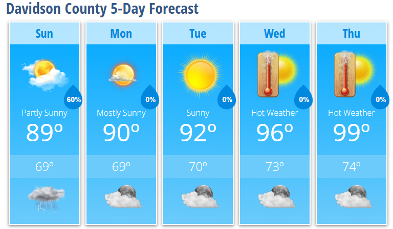
Sunday will feature partly sunny skies with a 60% chance of showers and thunderstorms. A few showers or storms could develop before the afternoon, but the greatest opportunity for more widespread thunderstorm activity will be from the afternoon into the early evening.
While there is still uncertainty regarding exactly how storms evolve, the atmosphere will remain capable of supporting strong to severe thunderstorms, especially if enough sunshine develops during the day. The primary threats will be damaging straight-line wind gusts, torrential rainfall, dangerous cloud-to-ground lightning, and localized flooding. Although the risk is low, an isolated tornado cannot be completely ruled out if storms become more organized.
High temperatures will reach around 89 degrees, with warm and humid conditions making it feel even warmer.
Any showers and thunderstorms will diminish Sunday evening, with skies becoming mostly clear overnight and temperatures falling to around 69 degrees.
Beginning Monday, the weather pattern shifts dramatically.
A strengthening upper-level ridge will expand across the eastern United States, leading to a prolonged stretch of dangerous heat. Temperatures will climb to 90 degrees Monday, 92 degrees Tuesday, 96 degrees Wednesday, and 99 degrees Thursday.
The hottest weather is expected Thursday, Friday and possibly into the Independence Day holiday weekend. Afternoon temperatures in the upper 90s to near 100 degrees, combined with warm overnight lows in the 70s, will increase the risk of heat-related illnesses. While afternoon dew points may mix out somewhat, dangerous heat remains increasingly likely.
Rain chances also decrease significantly after Monday, with only isolated mountain thunderstorms expected for much of the week.
Davidson County Forecast
Sunday
- Partly sunny.
- High: 89°
- 60% chance of showers and thunderstorms.
Sunday Night
- 30% chance of evening showers and thunderstorms.
- Becoming mostly clear overnight.
- Low: 69°
Monday
- Mostly sunny.
- High: 90°
Tuesday
- Sunny.
- High: 92°
Wednesday
- Sunny.
- High: 96°
Thursday
- Sunny and hot.
- High: 99°
What I'm Watching
- Sunday: Showers and thunderstorms are expected to redevelop during the afternoon and evening. A few storms could become strong to severe with damaging wind gusts, heavy rainfall and dangerous lightning.
- Late Week: Confidence continues to increase that a significant heat wave will develop across the region. Temperatures will approach 100 degrees by Thursday, with dangerous heat likely continuing into the Independence Day holiday weekend.
- Overnight Heat: Warm nighttime temperatures will offer little relief, increasing the cumulative impacts of several consecutive days of hot weather.
I'll continue monitoring Sunday's storm potential along with the increasingly dangerous heat expected later this week and will provide updates as forecast confidence continues to increase.