Weekend Storm Chances Continue Before Dangerous Heat Builds Across Davidson County Next Week
Scattered showers and thunderstorms remain in the forecast across Davidson County this weekend before a prolonged stretch of dangerous heat settles into the region next week.
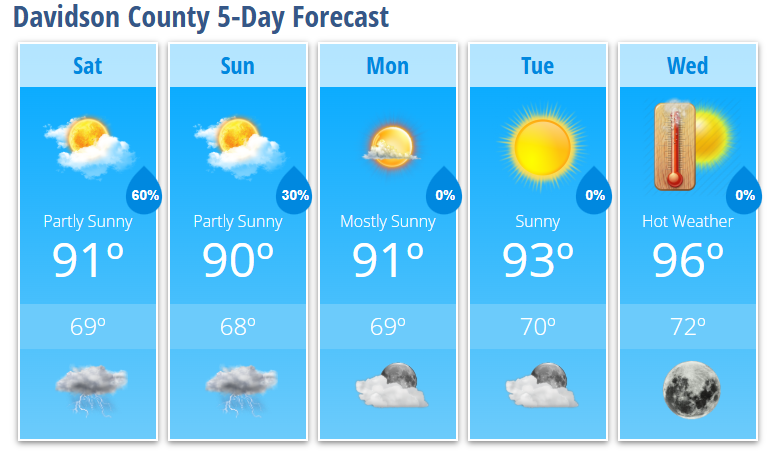
Today will be partly sunny with a high near 91 degrees. A 30% chance of showers and thunderstorms develops after 3:00 PM. While many communities will stay dry, any storm that develops could become strong to severe. The primary threats will be damaging wind gusts of 50 to 70 mph, frequent lightning, heavy rainfall, and isolated hail.
Storms become more likely this evening, with a 60% chance of showers and thunderstorms before 10:00 PM. Locally heavy rainfall is possible before activity gradually diminishes overnight. Temperatures will fall to around 69 degrees.
Sunday brings another opportunity for scattered thunderstorms, mainly after 5:00 PM. Highs will reach around 90 degrees. While the overall setup differs from today, there is still a risk for a few strong storms capable of producing damaging winds. Exactly how Sunday's weather evolves will depend on how much today's storms impact the atmosphere.
Beginning Monday, the weather pattern shifts as a strong area of high pressure expands across the eastern United States.
Temperatures will climb steadily through the week, reaching 93 degrees Tuesday and 96 degrees Wednesday, with even hotter conditions expected heading into the Independence Day holiday weekend.
The combination of high temperatures and humidity could push heat index values above 105 degrees, especially later in the week. Some locations across the Piedmont could approach 100-degree air temperatures, while overnight lows may struggle to fall below 80 degrees in some areas, providing little relief from the heat.
If you have outdoor plans next week or during the July 4th holiday, now is the time to begin preparing for several days of dangerous heat.
Davidson County Forecast
Today
- Partly sunny.
- High: 91°
- 30% chance of thunderstorms after 3 PM.
- A few storms could become severe with damaging wind gusts.
Tonight
- Showers and thunderstorms likely this evening.
- 60% chance of rain.
- Low: 69°
Sunday
- Partly sunny.
- High: 90°
- 30% chance of thunderstorms after 5 PM.
Sunday Night
- Partly cloudy.
- 30% chance of evening thunderstorms.
- Low: 68°
Monday
- Mostly sunny.
- High: 91°
Tuesday
- Sunny.
- High: 93°
Wednesday
- Sunny and hot.
- High: 96°
What I'm Watching
- This afternoon and evening: Davidson County remains under a Level 2 of 5 Slight Risk for severe thunderstorms, with damaging wind gusts being the primary concern.
- Sunday: Another round of scattered thunderstorms is possible, with a lower but continued severe weather risk.
- Midweek through the July 4th holiday: Confidence continues to increase in a prolonged and potentially dangerous heat wave, with heat index values likely exceeding 105 degrees and very warm overnight temperatures limiting nighttime relief.
I'll continue monitoring both the severe weather threat this weekend and the increasing heat expected next week, providing updates if conditions change.