Weekend Storm Chances Continue Before Dangerous Heat Builds Across Davie County Next Week
Scattered showers and thunderstorms remain in the forecast across Davie County this weekend before a prolonged stretch of summer heat settles into the region next week.
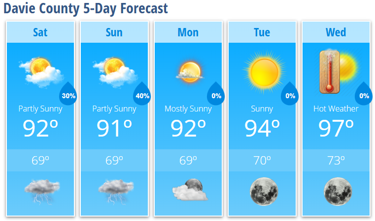
Today will be partly sunny with a high near 92 degrees. Scattered thunderstorms are expected to develop after 2:00 PM, with a 30% chance of rain. While many locations may remain dry, any storm that develops could become strong. The primary threat will be damaging wind gusts, along with heavy rainfall and frequent lightning.
Storms will gradually diminish this evening, with a few lingering showers possible before 1:00 AM. Overnight temperatures will fall to around 69 degrees.
Sunday brings another opportunity for scattered afternoon and evening thunderstorms. High temperatures will reach around 91 degrees, and storm chances increase slightly to 40% during the afternoon. While the overall severe weather threat appears lower than today, I'll continue monitoring for any organized clusters of storms that could move into the area.
Beginning Monday, the weather pattern shifts as high pressure strengthens across the eastern United States.
Temperatures will climb into the lower and middle 90s early in the week before reaching 97 degrees by Wednesday. Combined with increasing humidity, heat index values are expected to exceed 100 degrees across the area by midweek, with the potential for several consecutive days of dangerous heat.
If you have outdoor plans next week, be prepared for the increasing heat by staying hydrated, taking frequent breaks in the shade or air conditioning, and limiting strenuous outdoor activity during the hottest part of the day.
Davie County Forecast
Today
- Partly sunny.
- High: 92°
- 30% chance of thunderstorms after 2 PM.
- A few storms could become strong with damaging wind gusts.
Tonight
- 30% chance of showers and thunderstorms early.
- Mostly cloudy.
- Low: 69°
Sunday
- Partly sunny.
- High: 91°
- 40% chance of afternoon and evening thunderstorms.
Sunday Night
- Partly cloudy.
- 30% chance of evening thunderstorms.
- Low: 69°
Monday
- Mostly sunny.
- High: 92°
Tuesday
- Sunny.
- High: 94°
Wednesday
- Sunny and hot.
- High: 97°
What I'm Watching
- This afternoon and evening: Isolated strong to severe thunderstorms capable of producing damaging wind gusts.
- Sunday: Another round of scattered thunderstorms is possible, although confidence in exact timing remains lower.
- Next week: A prolonged period of hot weather develops, with heat index values likely exceeding 100 degrees by the middle of the week and potentially continuing into the Independence Day holiday period.
I'll continue monitoring both the storm potential this weekend and the increasing heat expected next week and will provide updates as conditions warrant.