Davidson County Forecast: Weekend Storm Chances Continue Before Next Week's Heat Intensifies
Good Friday afternoon! Here's my latest forecast for Davidson County.
The weather pattern remains active through the weekend with isolated afternoon and evening thunderstorms possible each day. While not everyone will see rain, any storm that develops could briefly become strong. Beyond the weekend, the focus quickly shifts to a prolonged stretch of dangerous summer heat.
Saturday
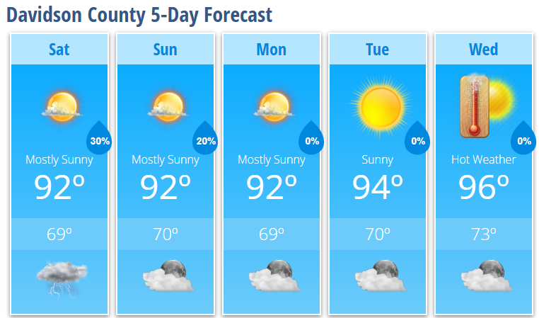
Saturday will be mostly sunny and warm with a high near 92 degrees.
There is a 30% chance of showers and thunderstorms after 4 PM. While widespread severe weather is not expected, a few stronger storms could produce gusty winds, frequent lightning, and brief heavy downpours during the late afternoon and evening.
Saturday night brings a 30% chance of lingering showers and thunderstorms before 10 PM, followed by partly cloudy skies and a low around 69 degrees.
Sunday
Sunday looks very similar with mostly sunny skies and highs around 92 degrees. Only an isolated afternoon or evening thunderstorm is expected, and many locations will remain dry.
Early Next Week
Monday stays mostly sunny with a high near 92 degrees, but temperatures begin climbing as we move into the middle of the week.
Tuesday reaches 94 degrees, followed by 96 degrees on Wednesday. Forecast guidance continues to indicate an extended period of dangerous heat developing during the second half of next week as we approach the Independence Day holiday.
By late next week, afternoon temperatures could approach 100 degrees, while heat index values may climb into the 105° to 110° range. Warm overnight temperatures in the 70s will provide little relief, making it important to begin planning now if you'll be spending extended time outdoors.
My Forecast Highlights
- Isolated afternoon and evening thunderstorms remain possible through the weekend.
- Any storm that develops could produce gusty winds, frequent lightning, and brief heavy rainfall.
- Temperatures remain in the lower 90s through Monday before climbing into the mid-90s by midweek.
- Heat index values above 100° become increasingly likely next week, with even hotter conditions possible by the July 4th holiday.
- I'll continue monitoring forecast trends as what could become a prolonged period of dangerous heat takes shape.
Davidson County Forecast
Saturday: Mostly sunny. High 92°. 30% chance of afternoon thunderstorms.
Saturday Night: Partly cloudy. Low 69°. 30% chance of evening thunderstorms.
Sunday: Mostly sunny. High 92°. 20% chance of an afternoon thunderstorm.
Sunday Night: Partly cloudy. Low 70°. 20% chance of an evening shower or thunderstorm.
Monday: Mostly sunny. High 92°.
Monday Night: Mostly clear. Low 69°.
Tuesday: Sunny. High 94°.
Tuesday Night: Mostly clear. Low 70°.
Wednesday: Sunny. High 96°.
Wednesday Night: Mostly clear. Low 73°.