Davie County Forecast: Weekend Storm Chances Increase Before Next Week's Heat Arrives
Good Friday morning! Here's my latest forecast for Davie County.
After a few quieter days, our typical summertime weather pattern is making a return. We'll see increasing opportunities for afternoon and evening thunderstorms through the weekend, followed by a noticeable increase in heat as we head into next week.
Today
Expect increasing clouds mixed with sunshine as temperatures climb to around 90 degrees. A 20% chance of showers and thunderstorms develops after 2 PM. Most of Davie County will remain dry, but any storm that forms could produce brief heavy rain, gusty winds, and frequent lightning.
Tonight, only a slight chance of a shower or thunderstorm lingers before midnight. Overnight lows will settle around 69 degrees under partly cloudy skies.
Saturday
Saturday looks to be the most active day of the weekend with a 40% chance of afternoon and evening thunderstorms. High temperatures will reach around 90 degrees.
The atmosphere will become increasingly unstable during the afternoon, and a few storms could become strong. Damaging wind gusts, torrential downpours, and frequent lightning will be the primary concerns. Not everyone will see rain, but those who do could experience a quick burst of severe weather.
Saturday night brings a few lingering storms before skies gradually clear.
Sunday
Sunday turns hotter with highs reaching around 93 degrees. Only isolated afternoon thunderstorms are expected, but I'll continue monitoring the potential for storms to organize upstream and move into the area. If that happens, a few stronger storms would once again be possible.
Early Next Week
The focus quickly shifts from storms to heat.
Monday and Tuesday remain mostly sunny with highs in the lower to middle 90s, and temperatures will likely continue climbing through the middle of next week. Heat index values could approach or exceed 100 degrees by Wednesday as a strong ridge of high pressure builds over the Southeast.
Rain chances will become more limited as that high pressure strengthens.
My Forecast Highlights
- Afternoon and evening thunderstorm chances return today and continue through the weekend.
- Saturday has the greatest chance for scattered storms, with a few capable of becoming strong.
- Temperatures climb into the lower to middle 90s beginning Sunday and continue through next week.
- Heat index values could reach the triple digits by the middle of next week.
- I'll continue watching this weekend's storm potential and provide updates if conditions warrant.
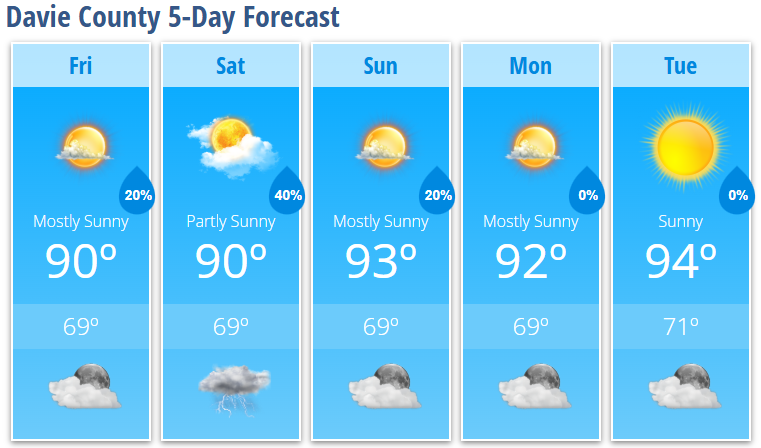
Davie County Forecast
Friday: Increasing clouds. High 90°. 20% chance of afternoon thunderstorms.
Friday Night: Partly cloudy. Low 69°. 20% chance of evening showers or storms.
Saturday: Partly sunny. High 90°. 40% chance of afternoon thunderstorms.
Saturday Night: Partly cloudy. Low 69°. 30% chance of early evening storms.
Sunday: Mostly sunny. High 93°. 20% chance of afternoon thunderstorms.
Sunday Night: Partly cloudy. Low 69°.
Monday: Mostly sunny. High 92°.
Monday Night: Mostly clear. Low 69°.
Tuesday: Sunny. High 94°.
Tuesday Night: Mostly clear. Low 71°.